1957 Map of Wisconsin Dells
USGS Topo · Published 1959About this map
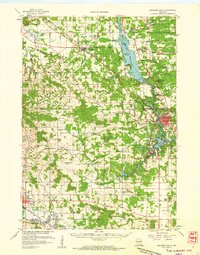
The Wisconsin River carves a dramatic path through this central Wisconsin landscape, defining the character of the region as it flows past Blackhawk Island and into The Narrows. By the late 1950s, the area had established itself as a distinct corridor of tourism and transportation, with the Chicago Milwaukee St Paul and Pacific railroad threading through Lyndon Station and Wisconsin Dells. The mapping of landmarks like Stand Rock, Steamboat Rock, and Witches Gulch underscores the geological curiosity that drew early visitors to the Dells.
Find a feature on this map
85 named features on this map. Tap any name to fly to it.
Don’t see what you’re looking for? This feature index may not catch every label — zoom into the map to look around manually.
Map Details
Editions of this 1957 Wisconsin Dells Map
This is the sole edition of this map. No revisions or reprints were ever made.
Historical Maps of Reedsburg Through Time
3 maps found

