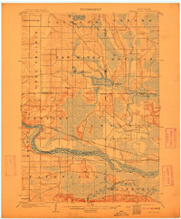
1902 Map of Briggsville
USGS Topo · Published 1912About this map
The Wisconsin River cuts a wide path through this central Wisconsin landscape at the dawn of the twentieth century, marking the divide between Columbia and Sauk counties. The northern reaches of the quadrangle are anchored by Briggsville on the shores of Mason Lake, a village that served as a local hub for the surrounding townships of Douglas and New Haven. The area's transportation network is defined by the Chicago Milwaukee and St. Paul RR, which tracks closely alongside a substantial Levee protecting the lowlands near Lewiston. To the west, the broad, flat expanse of Dell Prairie contrasts with the winding watercourses of Neenah Creek and the Baraboo River. These features illustrate the vital role of water and rail in shaping early settlement patterns, from small rural centers like Big Spring to the scattered homesteads along the shores of Jordan Lake.
Find a feature on this map
28 named features on this map. Tap any name to fly to it.
Don’t see what you’re looking for? This feature index may not catch every label — zoom into the map to look around manually.
Map Details
Editions of this 1902 Briggsville Map
4 editions found
Other maps of this area

1895 · Baraboo
USGS Topo · 1:62,500

1901 · Denzer
USGS Topo · 1:62,500

1901 · Poynette
USGS Topo · 1:62,500

1901 · The Dells
USGS Topo · 1:62,500

1902 · Portage
USGS Topo · 1:62,500

1902 · Briggsville
USGS Topo · 1:62,500

1908 · Baraboo
USGS Topo · 1:62,500

1957 · Wisconsin Dells
USGS Topo · 1:62,500

1957 · Madison
USGS Topo · 1:250,000

1958 · Briggsville
USGS Topo · 1:62,500