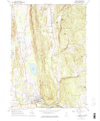
1963 Map of Bristol
USGS Topo · Published 1974About this map
The Hogback Mountains dominate the central spine of this landscape, creating a dramatic physical divide between the valley settlements. To the west, East Monkton sits along the drainage of Pond Brook, while to the east, the village of Starksboro follows the narrow corridor of Lewis Creek. This 1960s-era geography shows a region deeply rooted in its local history, evidenced by the high concentration of small family and community burial grounds such as Green Mount Cem, Robinson Sch Cem, and East Monkton Cem. The town of Bristol serves as the southern hub, situated where the New Haven River emerges from the steep terrain near Rocky Dale. Cultural landmarks like Howden Hall and the Mountain Street Sch anchor the Bristol village center, while the presence of the Bristol Airport and various Gravel Pits reflects the mid-century infrastructure supporting the local economy.
Find a feature on this map
47 named features on this map. Tap any name to fly to it.
Don’t see what you’re looking for? This feature index may not catch every label — zoom into the map to look around manually.
Map Details
Editions of this 1963 Bristol Map
3 editions found
Other maps of this area

1903 · Middlebury
USGS Topo · 1:62,500

1905 · Middlebury
USGS Topo · 1:62,500

1906 · Burlington
USGS Topo · 1:62,500

1919 · Burlington
USGS Topo · 1:62,500

1919 · Lincoln Mountain
USGS Topo · 1:62,500

1920 · Lincoln Mountain
USGS Topo · 1:48,000

1920 · Middlebury
USGS Topo · 1:62,500

1921 · Richmond
USGS Topo · 1:48,000

1921 · Lincoln Mountain
USGS Topo · 1:62,500

1924 · Camels Hump
USGS Topo · 1:62,500