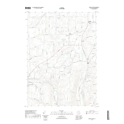
2019 Map of Bristol Center
USGS Topo · Published 2019About this map
Bristol Valley forms the central spine of this landscape, where North-flowing Mud Cr carves a path between steep ridges and high points like Johnson Hill and Stid Hill. The settlement patterns here reflect a rural Ontario County character, with clusters of development at South Bloomfield and Bristol Center. The topography is marked by several deeply incised "gullies" and "valleys," including Abbey Gulf, Jason Gully, and Egypt Valley, which illustrate the region's complex glacial drainage history.
Find a feature on this map
105 named features on this map. Tap any name to fly to it.
Don’t see what you’re looking for? This feature index may not catch every label — zoom into the map to look around manually.
Map Details
Editions of this 2019 Bristol Center Map
This is the sole edition of this map. No revisions or reprints were ever made.
Other maps of this area

1900 · Naples
USGS Topo · 1:62,500

1900 · Canandaigua
USGS Topo · 1:62,500

1901 · Honeoye
USGS Topo · 1:62,500

1902 · Wayland
USGS Topo · 1:62,500

1903 · Naples
USGS Topo · 1:62,500

1903 · Canandaigua
USGS Topo · 1:62,500

1904 · Wayland
USGS Topo · 1:62,500

1904 · Honeoye
USGS Topo · 1:62,500

1913 · Naples
USGS Topo · 1:62,500
1934 · Honeoye Falls
USGS Topo · 1:24,000