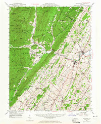
1947 Map of Broadway
USGS Topo · Published 1965About this map
The North Fork Shenandoah River carves a path through the heart of Rockingham County, anchoring a landscape where agricultural valleys meet the forested slopes of the George Washington National Forest. Near the dramatic water gap of Brocks Gap, the settlements of Broadway and Timberville emerge as centers of commerce along the Southern railway line. This late-1940s landscape is densely populated with community markers, from the rural crossroads at Cootes Store to a high concentration of country sanctuaries like Hebron Ch, Trissel Ch, and Mt Zion Ch. To the west, the terrain rises sharply into the ridge-and-valley system of the Appalachians, featuring landmarks like Chimney Rock and Buffalo Clover Knob. The presence of Melrose Caverns and the resort character of Sparkling Springs suggest a region transitioning between its deep farming roots and the growth of local tourism and industry.
Find a feature on this map
126 named features on this map. Tap any name to fly to it.
Don’t see what you’re looking for? This feature index may not catch every label — zoom into the map to look around manually.
Map Details
Editions of this 1947 Broadway Map
2 editions found

Other maps of this area

1892 · Franklin
USGS Topo · 1:125,000

1892 · Woodstock
USGS Topo · 1:125,000

1892 · Harrisonburg
USGS Topo · 1:125,000

1894 · Staunton
USGS Topo · 1:125,000

1896 · Franklin
USGS Topo · 1:125,000

1920 · Petersburg
USGS Topo · 1:48,000

1921 · Orkney Springs
USGS Topo · 1:48,000

1921 · Petersburg
USGS Topo · 1:48,000

1922 · Fort Seybert
USGS Topo · 1:48,000

1922 · Petersburg
USGS Topo · 1:62,500