1950 Map of Broadway
USGS Topo · Published 1950About this map
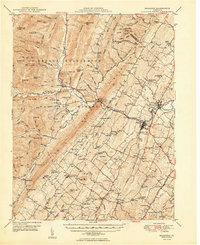
Broadway and Timberville anchor this mid-century look at the Shenandoah Valley, where the Southern railroad connects small farming communities along the North Fork River. The landscape transitions from the agricultural flats of Linville and Lacey Spring into the ridges of the George Washington National Forest. Evidence of a deep-rooted rural society is found in the high density of country churches and schools, such as Trissel Ch, Linville Creek Ch, and the Runion Creek Sch nestled near Church Mountain. Significant landmarks like Melrose Caverns and the resort-like Sparkling Springs reflect the local economy's blend of natural attractions and agriculture. Notable terrain features including Brocks Gap and Chimney Rock mark the passage into the western mountains, while small settlements like Singers Glen and Turleytown remain centers of local heritage.
Find a feature on this map
121 named features on this map. Tap any name to fly to it.
Don’t see what you’re looking for? This feature index may not catch every label — zoom into the map to look around manually.
Map Details
Editions of this 1950 Broadway Map
This is the sole edition of this map. No revisions or reprints were ever made.
Other maps of this area

1892 · Franklin
USGS Topo · 1:125,000

1892 · Woodstock
USGS Topo · 1:125,000

1892 · Harrisonburg
USGS Topo · 1:125,000

1894 · Staunton
USGS Topo · 1:125,000

1896 · Franklin
USGS Topo · 1:125,000

1920 · Petersburg
USGS Topo · 1:48,000

1921 · Orkney Springs
USGS Topo · 1:48,000

1921 · Petersburg
USGS Topo · 1:48,000

1922 · Fort Seybert
USGS Topo · 1:48,000

1922 · Petersburg
USGS Topo · 1:62,500