
Loading...
Loading map...2023 Map of Brockport
USGS Topo · Published 2023About this map
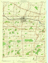
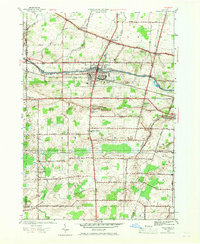
Brockport serves as the central hub of this Monroe County landscape, where the historic Erie Canal cuts through the northern half of the village. The town's character is defined by the significant campus of The College at Brockport, which occupies a large footprint south of Holley St. Outside the village center, the terrain is dotted with small rural settlements and cemeteries that trace the region’s early development, including West Sweden and Sweden Center.
Find a feature on this map
106 named features on this map. Tap any name to fly to it.
Don’t see what you’re looking for? This feature index may not catch every label — zoom into the map to look around manually.
Map Details
Date Portrayed2023
Date Published2023
PublisherU.S. Geological Survey
Map TypeTopographic
Scale1:24000
Physical Dimensions24 x 29 inches
Editions of this 2023 Brockport Map
This is the sole edition of this map. No revisions or reprints were ever made.
Historical Maps of Monroe County Through Time
4 maps found

Featured Locations
Source Details
SourceU.S. Geological Survey
CopyrightPublic Domain