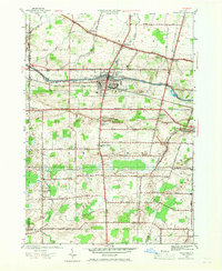
1934 Map of Brockport
USGS Topo · Published 1934About this map
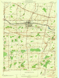
Barge Canal waters and the New York Central Railroad corridor define the industrial and transit heart of Brockport in this mid-1930s survey. The village serves as a dense hub surrounded by the agricultural townships of Clarkson and Sweden, where a network of school districts like School No 1 and School No 14 mark the rural landscape. The map captures the prominence of historic travel routes such as Ridge Road, which passes through Garland and Clarkson, while smaller hamlets like Sweden Center and West Sweden anchor the southern farmsteads. Local genealogists will find significant detail in the distribution of family burial grounds, including the Lake View Cemetery and East Sweden Cem, as well as the specialized infrastructure of the canal era such as the Guard Gate west of the village.
Find a feature on this map
66 named features on this map. Tap any name to fly to it.
Don’t see what you’re looking for? This feature index may not catch every label — zoom into the map to look around manually.
Map Details
Editions of this 1934 Brockport Map
This is the sole edition of this map. No revisions or reprints were ever made.
Historical Maps of Ogden Through Time
8 maps found