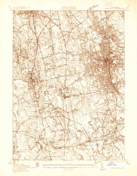
1936 Map of Brockton
USGS Topo · Published 1936About this map
Brockton serves as the industrial and social hub of this 1936 survey, showing a dense urban grid bordered by the extensive D W Field Park and the Brockton Reservoir. The surrounding landscape is a complex network of hamlets and family-named corners such as Daley Corner and Morse Corner, illustrating the transition from the city's manufacturing core to the specialized agricultural outskirts. This agricultural heritage is particularly evident in the Meadow Lea Cranberry Bog and the Oconnors Cider Mill near the edge of the Hockomock Swamp.
Find a feature on this map
93 named features on this map. Tap any name to fly to it.
Don’t see what you’re looking for? This feature index may not catch every label — zoom into the map to look around manually.
Map Details
Editions of this 1936 Brockton Map
This is the sole edition of this map. No revisions or reprints were ever made.
Other maps of this area

1885 · Abington
USGS Topo · 1:62,500

1885 · Middleboro
USGS Topo · 1:62,500

1885 · Taunton
USGS Topo · 1:62,500

1886 · Dedham
USGS Topo · 1:62,500

1888 · Taunton
USGS Topo · 1:62,500

1888 · Middleboro
USGS Topo · 1:62,500

1888 · Abington
USGS Topo · 1:62,500

1893 · Abington
USGS Topo · 1:62,500

1893 · Taunton
USGS Topo · 1:62,500

1893 · Middleboro
USGS Topo · 1:62,500