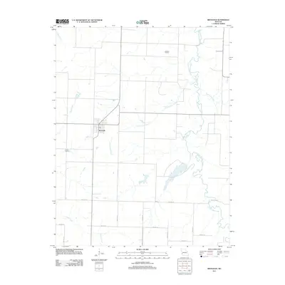
2011 Map of Bronaugh
USGS Topo · Published 2011About this map
Bronaugh serves as the primary hub of this Vernon County landscape, situated at the intersection of rural routes that crisscross a terrain defined by its complex drainage network. The geography is shaped by the winding course of Little Dry Wood Creek and its various tributaries, including Prairie Flower Branch and Pleasant Run Creek. This area maintains a strong agricultural character, evidenced by the grid-like road system consisting of routes such as NW 100th RD and NW 90th RD. For those researching local heritage, the map identifies significant land-use markers including McMullin Cemetery in the northeast and Worsley Cemetery to the west. The distribution of these features suggests a community deeply rooted in its pastoral environment, where small streams like McKill Creek and Comstock Creek provide natural boundaries between generational farmsteads.
Find a feature on this map
19 named features on this map. Tap any name to fly to it.
Don’t see what you’re looking for? This feature index may not catch every label — zoom into the map to look around manually.
Map Details
Editions of this 2011 Bronaugh Map
This is the sole edition of this map. No revisions or reprints were ever made.
Other maps of this area

1884 · Fort Scott
USGS Topo · 1:125,000

1886 · Nevada
USGS Topo · 1:125,000

1886 · Fort Scott
USGS Topo · 1:125,000

1893 · Fort Scott
USGS Topo · 1:125,000

1894 · Nevada
USGS Topo · 1:125,000

1933 · Camp Clark
USGS Topo · 1:24,000

1939 · Deerfield
USGS Topo · 1:24,000

1939 · Moundville
USGS Topo · 1:24,000

1942 · Deerfield
USGS Topo · 1:24,000
1942 · Moundville
USGS Topo · 1:24,000