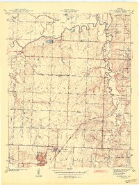
1942 Map of Moundville
USGS Topo · Published 1942About this map
The Marmaton River meanders across this rural Vernon County landscape, defining the northern boundary where oxbows and sloughs like Bens Slough and Lively Lake suggest a dynamic floodplain. Surveyed just before the Second World War, the area is anchored by the small settlements of Moundville and Ellis, both situated along the Missouri Pacific railroad corridor. A dense network of local country schools, including Hazel Dell Sch, Nash Sch, and Carl Sch, reveals a distributed rural population that relied on these local hubs for education and community life. The convergence of the Missouri Kansas Texas and Missouri Pacific lines highlights the region's historical reliance on rail for transporting agricultural goods. Further south, the terrain becomes more dissected by drainage systems such as Dry Wood Creek and Hattons Slough, where the Wilburn Cem serves as a significant genealogical marker for early families in Deerfield and Moundville townships.
Find a feature on this map
37 named features on this map. Tap any name to fly to it.
Don’t see what you’re looking for? This feature index may not catch every label — zoom into the map to look around manually.
Map Details
Editions of this 1942 Moundville Map
2 editions found
Other maps of this area

1884 · Fort Scott
USGS Topo · 1:125,000

1886 · Nevada
USGS Topo · 1:125,000

1886 · Fort Scott
USGS Topo · 1:125,000

1893 · Fort Scott
USGS Topo · 1:125,000

1894 · Nevada
USGS Topo · 1:125,000

1933 · Camp Clark
USGS Topo · 1:24,000

1938 · Metz
USGS Topo · 1:24,000

1938 · Horton
USGS Topo · 1:24,000

1939 · Metz
USGS Topo · 1:24,000

1939 · Horton
USGS Topo · 1:24,000