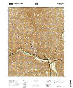
2019 Map of Brookneal
USGS Topo · Published 2019About this map
The Roanoke River and Falling River converge at the center of this map, marking a complex boundary where Campbell, Halifax, and Charlotte Counties meet. At this river junction, Brookneal serves as the primary settlement, its residential streets and the Brookneal Reservoir framed by the winding water courses. This 2019 survey documents the landscape's transition from the dense street grids of the town center to the outlying rural communities and family-named landmarks that define the region.
Find a feature on this map
99 named features on this map. Tap any name to fly to it.
Don’t see what you’re looking for? This feature index may not catch every label — zoom into the map to look around manually.
Map Details
Editions of this 2019 Brookneal Map
This is the sole edition of this map. No revisions or reprints were ever made.
Other maps of this area

1892 · Lynchburg
USGS Topo · 1:125,000

1892 · Appomattox
USGS Topo · 1:125,000

1947 · Roanoke
USGS Topo · 1:250,000

1953 · Greensboro
USGS Topo · 1:250,000

1954 · Greensboro
USGS Topo · 1:250,000

1954 · Halifax
USGS Topo · 1:62,500

1954 · Riceville
USGS Topo · 1:62,500

1956 · Brookneal
USGS Topo · 1:62,500

1956 · Gladys
USGS Topo · 1:62,500

1959 · Roanoke
USGS Topo · 1:250,000