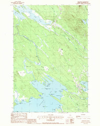
1988 Map of Brookton
USGS Topo · Published 1988About this map
Brookton serves as the primary center of activity in this northern Maine landscape, where the waters of Baskahegan Lake and the Baskahegan Stream dominate the local geography. The map reveals a transition from organized settlements like Eaton to more specialized areas such as Kinney Nation, reflecting the area's timber and recreational history. Detailed shoreline features along the lake, including the humorously named Uncle Sam Cove, Knownothing Cove, and Abraquidassat Point, provide high-resolution data for those studying the irregular geography of the region's inland waters. Inland, the terrain is marked by significant wetlands such as Webber Bog and the dramatic Hells Rapids, indicating the varied and often challenging nature of the waterways. This provisional survey captures the intersection of small-town life and the extensive hydrological networks that define this portion of Washington County.
Find a feature on this map
62 named features on this map. Tap any name to fly to it.
Don’t see what you’re looking for? This feature index may not catch every label — zoom into the map to look around manually.
Map Details
Editions of this 1988 Brookton Map
This is the sole edition of this map. No revisions or reprints were ever made.
Other maps of this area

1940 · Danforth
USGS Topo · 1:62,500

1940 · Waite
USGS Topo · 1:62,500

1940 · Forest
USGS Topo · 1:62,500

1941 · Danforth
USGS Topo · 1:62,500

1941 · Scraggly Lake
USGS Topo · 1:62,500

1942 · Waite
USGS Topo · 1:62,500

1942 · Forest
USGS Topo · 1:62,500

1943 · Danforth
USGS Topo · 1:62,500

1944 · Scraggly Lake
USGS Topo · 1:62,500

1957 · Fredericton
USGS Topo · 1:250,000