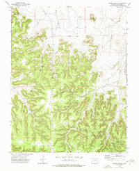
1972 Map of Brown Canyon
USGS Topo · Published 1976About this map
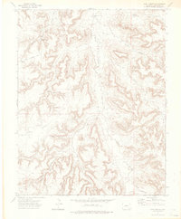
Wagon Gap and the prominent Lone Mesa anchor this landscape of the High Plains, where the drainage networks of Muddy Creek and Shawana Creek have carved deep canyon systems into the terrain. In the early 1970s, this area of Las Animas County was defined by a ranching infrastructure of windmills and isolated water sources. Named landmarks like Green Windmill, Sumpter Windmill, and Barber Windmill are scattered across the quadrangle, serving as vital reference points in a region otherwise dominated by complex topography like North Deadman Canyon and Shell Canyon. The map reveals a reliance on sparse water features such as Brown Spring and the Funk Reservoir, while human activity is further evidenced by a Gravel Pit and a lone Radio Tower near Long Canyon Hill.
Find a feature on this map
29 named features on this map. Tap any name to fly to it.
Don’t see what you’re looking for? This feature index may not catch every label — zoom into the map to look around manually.
Map Details
Editions of this 1972 Brown Canyon Map
This is the sole edition of this map. No revisions or reprints were ever made.
Other maps of this area

1891 · Higbee
USGS Topo · 1:125,000

1892 · Mt Carrizo
USGS Topo · 1:125,000

1893 · Higbee
USGS Topo · 1:125,000

1955 · La Junta
USGS Topo · 1:250,000

1958 · La Junta
USGS Topo · 1:250,000

1968 · La Junta
USGS Topo · 1:250,000
1971 · Ninaview
USGS Topo · 1:24,000
1971 · Plug Hat Ranch
USGS Topo · 1:24,000
1972 · Rock Canyon
USGS Topo · 1:24,000
1972 · Lost Canyon
USGS Topo · 1:24,000