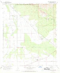
1968 Map of Brown Mountain
USGS Topo · Published 1969About this map
Tucson Mountain Park and the rugged eastern slopes of the Tucson Mountains dominate this late-sixties landscape. The map reveals a fascinating intersection of desert conservation and western heritage, most notably at the Old Tucson film set and the Arizona-Sonora Desert Museum. To the west, the arid Avra Valley spreads across the Papago Indian Reservation, defined by long stretches of Sandario Road and a major utility Pipeline. Isolated water sources like Robles Well and San Joaquin Well highlight the critical role of groundwater in this desert environment. In the southern reaches, aviation activity is centered at Ryan Field, supported by an Airway Beacon and a nearby Radio Tower. From the peaks of Brown Mountain to the flatlands of the valley, the survey documents a region balancing rural ranching at Phillips Ranch with emerging tourism and scientific study.
Find a feature on this map
35 named features on this map. Tap any name to fly to it.
Don’t see what you’re looking for? This feature index may not catch every label — zoom into the map to look around manually.
Map Details
Editions of this 1968 Brown Mountain Map
3 editions found
Other maps of this area

1925 · San Xavier
USGS Topo · 1:62,500

1934 · Tucson Mountains
USGS Topo · 1:125,000

1941 · Cocoraque Butte
USGS Topo · 1:62,500

1943 · Cocoraque Butte
USGS Topo · 1:62,500

1943 · San Xavier Mission
USGS Topo · 1:62,500

1947 · Cortaro
USGS Topo · 1:62,500

1956 · Tucson
USGS Topo · 1:250,000

1957 · San Xavier Mission
USGS Topo · 1:62,500

1957 · Cortaro
USGS Topo · 1:62,500

1958 · Tucson
USGS Topo · 1:250,000