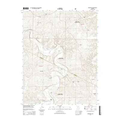
2015 Map of Brownfield
USGS Topo · Published 2015About this map
The Gasconade River meanders through the heart of this Missouri landscape, defining the boundary where Pulaski and Laclede counties meet. This 2015 survey reveals a terrain defined by deep hollows such as Laquey Hollow, Killman Hollow, and Mush Paddle Hollow, while much of the land is preserved within the Mark Twain National Forest. The map documents a scattered settlement pattern concentrated around Brownfield and Adam Ford, with numerous family and community burial grounds, including Rollins Cemetery, Nicks Cemetery, and Simpson Cemetery, providing vital data for genealogical research. The presence of Roubidoux Cr and Bell Br highlights the significance of local waterways in shaping the road network, which includes historically named routes like Smokey Rd and Fairview Rd.
Find a feature on this map
48 named features on this map. Tap any name to fly to it.
Don’t see what you’re looking for? This feature index may not catch every label — zoom into the map to look around manually.
Map Details
Editions of this 2015 Brownfield Map
This is the sole edition of this map. No revisions or reprints were ever made.
Other maps of this area

1936 · Waynesville
USGS Topo · 1:48,000

1941 · Big Piney
USGS Topo · 1:62,500

1942 · Waynesville
USGS Topo · 1:62,500

1943 · Richland
USGS Topo · 1:62,500

1943 · Big Piney
USGS Topo · 1:62,500

1943 · Drynob
USGS Topo · 1:62,500

1944 · Waynesville
USGS Topo · 1:62,500

1954 · Springfield
USGS Topo · 1:250,000

1954 · Drynob
USGS Topo · 1:62,500
1954 · Big Piney
USGS Topo · 1:62,500