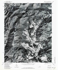
1977 Map of Browns Cove
USGS Topo · Published 1982About this map
Browns Cove and its surrounding mountain valleys are captured in this orthophotograph, reflecting the rural character of western Albemarle County in the late 1970s. The landscape is defined by the steep slopes of the Blue Ridge and Big Flat Mountain, where the famous Skyline Drive follows the high crest. Below the ridges, clearings for agriculture and small settlements like Mountfair and Doylesville occupy the more level ground near the water. The drainage of the North Fork Doyles River and the Doyles River dominates the central valley, while the Charlottesville Reservoir and the Moormans River are visible in the southern portion of the sheet. This aerial view provides a stark contrast between the forested wilderness of the mountain peaks and the cultivated farmsteads tucked into the river bottoms.
Find a feature on this map
11 named features on this map. Tap any name to fly to it.
Don’t see what you’re looking for? This feature index may not catch every label — zoom into the map to look around manually.
Map Details
Editions of this 1977 Browns Cove Map
This is the sole edition of this map. No revisions or reprints were ever made.
Other maps of this area

1892 · Harrisonburg
USGS Topo · 1:125,000

1931 · University
USGS Topo · 1:62,500

1934 · Waynesboro
USGS Topo · 1:48,000

1935 · University
USGS Topo · 1:62,500

1937 · Elkton
USGS Topo · 1:62,500

1939 · Waynesboro
USGS Topo · 1:62,500

1941 · Harrisonburg
USGS Topo · 1:62,500

1943 · Harrisonburg
USGS Topo · 1:62,500

1949 · Charlottesville
USGS Topo · 1:250,000

1956 · Charlottesville
USGS Topo · 1:250,000