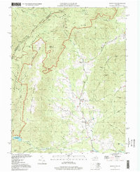
1997 Map of Browns Cove
USGS Topo · Published 1999About this map
Pasture Fence Mountain and the steep ridges of the Blue Ridge dominate this landscape on the border of Rockingham and Albemarle counties. In the late 1990s, the boundary of Shenandoah National Park carved through the highlands, separating the protected wilderness of Blackrock and Big Flat Mtn from the agricultural valleys below. Settled life concentrates along the Doyles River, where the communities of Mountfair and Doylesville sit at the base of Fox Mountain.
Find a feature on this map
60 named features on this map. Tap any name to fly to it.
Don’t see what you’re looking for? This feature index may not catch every label — zoom into the map to look around manually.
Map Details
Editions of this 1997 Browns Cove Map
This is the sole edition of this map. No revisions or reprints were ever made.
Other maps of this area

1892 · Harrisonburg
USGS Topo · 1:125,000

1931 · University
USGS Topo · 1:62,500

1934 · Waynesboro
USGS Topo · 1:48,000

1935 · University
USGS Topo · 1:62,500

1937 · Elkton
USGS Topo · 1:62,500

1939 · Waynesboro
USGS Topo · 1:62,500

1941 · Harrisonburg
USGS Topo · 1:62,500

1943 · Harrisonburg
USGS Topo · 1:62,500

1949 · Charlottesville
USGS Topo · 1:250,000

1956 · Charlottesville
USGS Topo · 1:250,000