1951 Map of Browns Mills
USGS Topo · Published 1951About this map
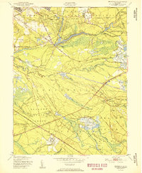
The Fort Dix Military Reservation dominates the northern portion of this landscape, its boundary enclosing a Rifle Range and an Observation Tower near the Deborah Sanatorium. In the heart of the Pine Barrens, the settlement of Browns Mills serves as a central hub, situated along the shores of Mirror Lake and near St Annes Ch. The geography is defined by the specialized agriculture of the region, specifically numerous Cranberry Bogs scattered throughout the drainage basins of Mount Misery Brook and Rancocas Creek North Branch. To the south, the expansive Lebanon State Forest provides a glimpse into the preserved woodlands and early industrial sites like Lower Mill and Upper Mill. Unusual place names such as Ongs Hat and Mount Misery underscore the distinct local history of this section of Burlington County.
Find a feature on this map
57 named features on this map. Tap any name to fly to it.
Don’t see what you’re looking for? This feature index may not catch every label — zoom into the map to look around manually.
Map Details
Editions of this 1951 Browns Mills Map
This is the sole edition of this map. No revisions or reprints were ever made.
Other maps of this area

1884 · Whitings
USGS Topo · 1:62,500

1888 · Bordentown
USGS Topo · 1:62,500

1888 · Pemberton
USGS Topo · 1:62,500

1888 · Cassville
USGS Topo · 1:62,500

1888 · Whitings
USGS Topo · 1:62,500

1893 · Bordentown
USGS Topo · 1:62,500

1894 · Cassville
USGS Topo · 1:62,500

1894 · Pemberton
USGS Topo · 1:62,500

1898 · Pemberton
USGS Topo · 1:62,500

1900 · Cassville
USGS Topo · 1:62,500
Featured Places
- Southampton Township, NJ
- Plumsted Township, NJ
- Wrightstown, NJ
- New Hanover Township, NJ
- Pemberton Township, NJ