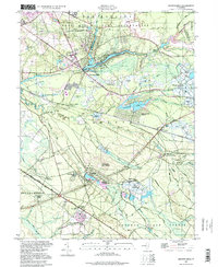
1997 Map of Browns Mills
USGS Topo · Published 1998About this map
Whitesbog and the surrounding pine barrens of Burlington County define this landscape, where a legacy of cranberry cultivation is visible through numerous Cranberry Bogs and specialized water management systems. The community of Browns Mills serves as a hub near the North Branch Rancocas Creek, sitting at the edge of the Fort Dix Military Reservation. This region, documented with data compiled in 1947 and updated via 1997 imagery, shows the established medical presence of the Deborah Sanatorium and the extensive acreage of the Lebanon State Forest. Industrial and agricultural history is etched into the terrain at Hanover Furnace and the small settlements of Mount Misery and Upton. The map preserves the locations of early rural infrastructure, including the Laurel Hill Sch and the rail-oriented Browns Mills Junction, alongside residential expansions like Presidential Lakes.
Find a feature on this map
71 named features on this map. Tap any name to fly to it.
Don’t see what you’re looking for? This feature index may not catch every label — zoom into the map to look around manually.
Map Details
Editions of this 1997 Browns Mills Map
This is the sole edition of this map. No revisions or reprints were ever made.
Other maps of this area

1884 · Whitings
USGS Topo · 1:62,500

1888 · Bordentown
USGS Topo · 1:62,500

1888 · Pemberton
USGS Topo · 1:62,500

1888 · Cassville
USGS Topo · 1:62,500

1888 · Whitings
USGS Topo · 1:62,500

1893 · Bordentown
USGS Topo · 1:62,500

1894 · Cassville
USGS Topo · 1:62,500

1894 · Pemberton
USGS Topo · 1:62,500

1898 · Pemberton
USGS Topo · 1:62,500

1900 · Cassville
USGS Topo · 1:62,500
Featured Places
- Southampton Township, NJ
- Plumsted Township, NJ
- Wrightstown, NJ
- New Hanover Township, NJ
- Pemberton Township, NJ