1956 Map of Brownsville
USGS Topo · Published 1980About this map
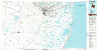
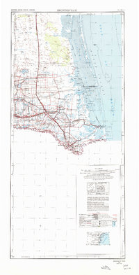
The Rio Grande Delta in the mid-1950s is defined by a dense network of irrigation and drainage infrastructure, including the Main Floodway and Arroyo Colorado. This survey captures the Lower Rio Grande Valley at a peak of agricultural and industrial development, where the Missouri Pacific and Southern Pacific railroads connect established citrus and vegetable centers like Harlingen, Raymondville, and San Benito. Along the coast, the Laguna Madre separates the mainland from the Padre Island National Seashore, showing the intricate barrier island geography before modern coastal expansion. Local educational and social hubs are documented at the Las Yescas School and Palm Grove School, while the Brownsville Ship Channel and Big Grande Valley International Airport signify the region's role as a vital international transit corridor between the United States and Mexico.
Find a feature on this map
91 named features on this map. Tap any name to fly to it.
Don’t see what you’re looking for? This feature index may not catch every label — zoom into the map to look around manually.
Map Details
Editions of this 1956 Brownsville Map
2 editions found

Historical Maps of Weslaco Through Time
4 maps found