1992 Map of Brownsville
USGS Topo · Published 1992About this map
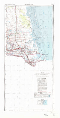
Rio Grande and Rio Bravo channel a landscape defined by binational growth and historical conflict during the early 1990s. This survey centers on the urban nexus of Brownsville and Matamoros, documenting the intricate system of resacas and lagoons that characterize the coastal delta, including Town Resaca and the expansive Laguna Madre system to the east. The map highlights significant historical grounds such as the Palo Alto Battlefield National Historic Site, the Resaca De La Palma Battlefield, and Palmito Hill Battlefield, marking the area's strategic military importance.
Find a feature on this map
238 named features on this map. Tap any name to fly to it.
Don’t see what you’re looking for? This feature index may not catch every label — zoom into the map to look around manually.
Map Details
Editions of this 1992 Brownsville Map
This is the sole edition of this map. No revisions or reprints were ever made.
Historical Maps of Brownsville Through Time
4 maps found