1953 Map of Brownsville
USGS Topo · Published 1953About this map
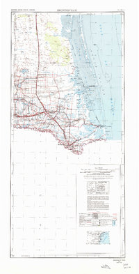
The Rio Grande delta region in the early 1950s is defined here by a complex network of irrigation floodways and international border commerce. Significant infrastructure like the Brownsville Ship Channel and the Rio Grande Valley International airport underscore the area's development as a maritime and aviation hub. Inland, the landscape is dotted with family-named outposts and legacy cattle operations such as Tecolote Ranch, Balls Ranch, and Yturria, interspersed with established agricultural centers like Raymondville and Lyford.
Find a feature on this map
153 named features on this map. Tap any name to fly to it.
Don’t see what you’re looking for? This feature index may not catch every label — zoom into the map to look around manually.
Map Details
Editions of this 1953 Brownsville Map
This is the sole edition of this map. No revisions or reprints were ever made.
Historical Maps of Weslaco Through Time
4 maps found