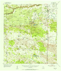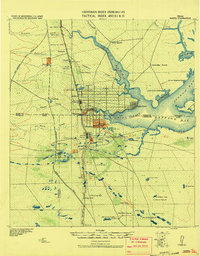
1928 Map of Sarita
USGS Topo · Published 1928About this map
The St. Louis Brownsville & Mexico Railway provides the primary north-south artery through this South Texas coastal landscape, crossing numerous wooden trestles over the tidal creeks feeding into Baffin's Bay. Surveyed originally in 1909 and updated in later military revisions, the map reveals a region dominated by large-scale cattle operations like the La Para Ranch and Jaboncillos Ranch. The presence of an Artesian Well Ditch and numerous scattered wells indicates the critical importance of groundwater management in this environment. Small hubs like Sarita and Riviera serve as railroad and ranching centers, while Riviera Beach and Jaboncillos Landing mark the early development of the waterfront along the Laguna Salado. The map captures the meeting of several county lines, including the Nueces, Cameron, and Hidalgo boundaries, during an era when large private ranch holdings were the defining feature of the geography.
Find a feature on this map
58 named features on this map. Tap any name to fly to it.
Don’t see what you’re looking for? This feature index may not catch every label — zoom into the map to look around manually.
Map Details
Editions of this 1928 Sarita Map
This is the sole edition of this map. No revisions or reprints were ever made.
Historical Maps of Kingsville Through Time
7 maps found