1917 Map of Ben Bolt
USGS Topo · Published 1956About this map
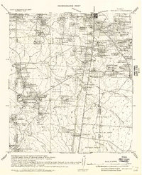
Large cattle ranches and early industrial infrastructure define this South Texas landscape during the era of military reconnaissance mapping. The ranching economy is evident in the numerous named family holdings such as the Hanson Ranch, Lopez Ranch, and Vilaria Ranch, alongside large grazing tracts like Barregos Pasture. Industrial activity is anchored by a Sugar Mill and vital livestock Shipping Pens, while the hub of Alice serves as a critical junction for regional transportation.
Find a feature on this map
117 named features on this map. Tap any name to fly to it.
Don’t see what you’re looking for? This feature index may not catch every label — zoom into the map to look around manually.
Map Details
Editions of this 1917 Ben Bolt Map
This is the sole edition of this map. No revisions or reprints were ever made.
Historical Maps of Alice Through Time
1 maps found