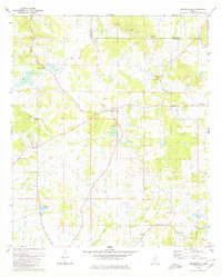
1980 Map of Brownsville
USGS Topo · Published 1980About this map
The boundary between Madison Co and Hinds Co cuts through this rural landscape north of the capital, centered on the community of Brownsville. This 1980 record illustrates a region defined by scattered churches and cemeteries that anchor the local geography. Significant landmarks include the Hill of Zion Ch situated near the distinctive Hill of Zion, and the Brownsville Lookout Tower standing as a sentinel over the wooded terrain. To the northwest, Orangeville sits near White Lake, while the eastern portion of the map is marked by the meandering path of Spring Creek and several gravel pits. The presence of named roads like Lorance Rd and Northside Drive shows the maturing local infrastructure serving small settlements and family-named cemeteries such as Abernathy Cem and Slay Cem.
Find a feature on this map
29 named features on this map. Tap any name to fly to it.
Don’t see what you’re looking for? This feature index may not catch every label — zoom into the map to look around manually.
Map Details
Editions of this 1980 Brownsville Map
This is the sole edition of this map. No revisions or reprints were ever made.
Other maps of this area

1903 · Jackson
USGS Topo · 1:125,000

1934 · Raymond
USGS Topo · 1:48,000

1937 · Raymond
USGS Topo · 1:62,500

1938 · Edwards
USGS Topo · 1:62,500

1940 · Mechanicsburg
USGS Topo · 1:62,500

1942 · Raymond
USGS Topo · 1:62,500

1955 · Jackson
USGS Topo · 1:250,000

1961 · Jackson
USGS Topo · 1:250,000

1962 · Jackson
USGS Topo · 1:250,000

1962 · Flora
USGS Topo · 1:62,500