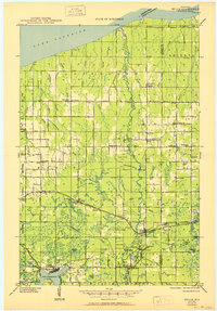
1947 Map of Brule
USGS Topo · Published 1950About this map
The Bois Brule River meanders northward toward the south shore of Lake Superior, defining the geography of this Northern Wisconsin landscape. Based on field work in 1945, the map shows a rural region transitionally forested and cleared for agriculture, centered on the village of Brule and the recreational hub of Lake Nebagamon. The Northern Pacific railroad provides the primary east-west corridor, connecting small settlements like Blueberry and Waino. Local life is anchored by a dense network of country schools and churches, including Waino Sch, Pioneer Sch, and Emmanuel Ch, reflecting the Scandinavian and Finnish heritage of the Lake Superior coastal plain. To the south, the Brule River State Forest and landmarks like the Stony Hill Fire Tower suggest the era's focus on conservation and fire prevention in the regrowing Northwoods.
Find a feature on this map
75 named features on this map. Tap any name to fly to it.
Don’t see what you’re looking for? This feature index may not catch every label — zoom into the map to look around manually.
Map Details
Editions of this 1947 Brule Map
2 editions found
Other maps of this area

1943 · Port Wing
USGS Topo · 1:48,000

1943 · Iron Lake
USGS Topo · 1:48,000

1944 · Drummond
USGS Topo · 1:48,000

1945 · Highland
USGS Topo · 1:48,000

1945 · Solon Springs
USGS Topo · 1:48,000

1946 · Port Wing
USGS Topo · 1:48,000

1947 · Drummond
USGS Topo · 1:48,000

1947 · Brule
USGS Topo · 1:48,000

1947 · Iron Lake
USGS Topo · 1:48,000

1949 · Solon Springs
USGS Topo · 1:48,000