
1947 Map of Brule
USGS Topo · Published 1947About this map
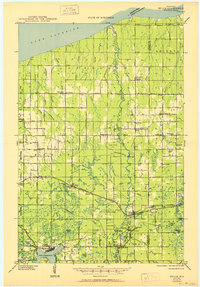
Bois Brule River snakes northward toward Lake Superior, anchoring a landscape of glacial lakes and managed timberlands in the years following World War II. The southern portion of the map is dominated by the sprawling Brule River State Forest and the significant shoreline of Lake Nebagamon, while the Northern Pacific railroad provides the primary east-west corridor for the timber and agricultural industries. Small, rural Finnish and Scandinavian-influenced settlements like Oulu and Waino are visible through their localized infrastructure, including the Oulu Ch, Waino Sch, and the Town Hall in Oulu. Localized history is further evidenced by the distribution of country schools such as Nelson Sch and Pioneer Sch, and the presence of a Fish Hatchery and Ranger Station along the river, reflecting the region's commitment to conservation and recreation.
Find a feature on this map
72 named features on this map. Tap any name to fly to it.
Don’t see what you’re looking for? This feature index may not catch every label — zoom into the map to look around manually.
Map Details
Editions of this 1947 Brule Map
2 editions found
Other maps of this area

1943 · Port Wing
USGS Topo · 1:48,000

1943 · Iron Lake
USGS Topo · 1:48,000
1944 · Drummond
USGS Topo · 1:48,000

1945 · Highland
USGS Topo · 1:48,000

1945 · Solon Springs
USGS Topo · 1:48,000
1946 · Port Wing
USGS Topo · 1:48,000
1947 · Drummond
USGS Topo · 1:48,000

1947 · Iron Lake
USGS Topo · 1:48,000

1949 · Solon Springs
USGS Topo · 1:48,000

1949 · Poplar
USGS Topo · 1:48,000