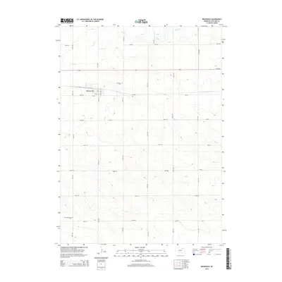
2014 Map of Brunswick
USGS Topo · Published 2014About this map
Brunswick anchors this northeastern Nebraska landscape, a small community organized along a strict grid of streets including Locust St and Franklin St. The local Po serves as a central landmark for this rural hub in Antelope County. Beyond the town limits, the geography is defined by the winding course of Bazile Creek, which meanders through the northern section of the quadrangle. For genealogists and local historians, the presence of the Brunswick Cemetery just north of town and the West Willowdale Cemetery in the southwest corner provide specific points of interest for tracing family history. The surrounding countryside is remarkably orderly, partitioned by an extensive network of rural roads such as 865 Road and 531st Avenue, reflecting the enduring agricultural character of the region during the early twenty-first century.
Find a feature on this map
29 named features on this map. Tap any name to fly to it.
Don’t see what you’re looking for? This feature index may not catch every label — zoom into the map to look around manually.
Map Details
Editions of this 2014 Brunswick Map
This is the sole edition of this map. No revisions or reprints were ever made.
Other maps of this area

1955 · Sioux City
USGS Topo · 1:250,000

1955 · O'Neill
USGS Topo · 1:250,000

1958 · Sioux City
USGS Topo · 1:250,000

1959 · O'Neill
USGS Topo · 1:250,000

1959 · Sioux City
USGS Topo · 1:250,000

1963 · Orchard NE
USGS Topo · 1:24,000

1963 · Neligh
USGS Topo · 1:24,000

1963 · Plainview
USGS Topo · 1:24,000

1963 · Brunswick
USGS Topo · 1:24,000
1963 · Tilden NE
USGS Topo · 1:24,000