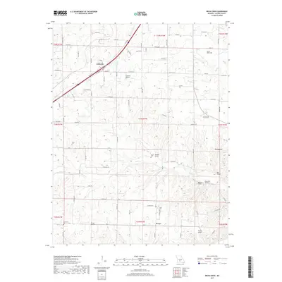
2017 Map of Brush Creek
USGS Topo · Published 2017About this map
Goodwin Hollow Cr and the drainage of Brush Cr define the landscape of eastern Laclede County in this modern survey. The map details a predominantly rural area marked by scattered settlements and significant genealogical landmarks. Small communities like Evergreen and Morgan anchor the southern reaches, while Caffeyville sits near the northern boundary. The terrain is notably dissected by various hollows, including Goodwin Hollow and Selvage Hollow, reflecting the region's typical Ozark topography. One of the more intriguing geological features is the Silver Mine Sink, located in the northeastern corner near Hwy HH. Family history researchers will find several well-documented burial sites across the township lines, such as Kissee Cem, Roper Cem, and Builderback Cem, which provide points of reference for tracing early local residents along the county roads.
Find a feature on this map
89 named features on this map. Tap any name to fly to it.
Don’t see what you’re looking for? This feature index may not catch every label — zoom into the map to look around manually.
Map Details
Editions of this 2017 Brush Creek Map
This is the sole edition of this map. No revisions or reprints were ever made.
Other maps of this area

1939 · Long Lane
USGS Topo · 1:62,500

1941 · Lebanon
USGS Topo · 1:62,500

1942 · Long Lane
USGS Topo · 1:62,500

1943 · Lebanon
USGS Topo · 1:62,500

1946 · Niangua
USGS Topo · 1:62,500

1948 · Niangua
USGS Topo · 1:62,500

1954 · Springfield
USGS Topo · 1:250,000

1956 · Rader
USGS Topo · 1:24,000
1956 · Grovespring
USGS Topo · 1:24,000

1958 · Springfield
USGS Topo · 1:250,000