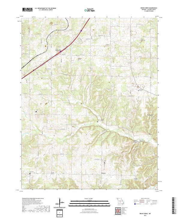
2021 Map of Brush Creek
USGS Topo · Published 2021About this map
Caffeyville and Morgan anchor this section of Laclede County, where the Ozark landscape is defined by its characteristic karst topography and complex drainage patterns. The presence of Silver Mine Sink in the northeast suggests the unique geological underpinnings of the region, while numerous named hollows like Goodwin Hollow, Wildcat Hollow, and Selvage Hollow illustrate the deeply dissected terrain carved by Brush Cr and its tributaries. Local history is preserved through a high density of small family and community burial grounds, including White Oak Pond Cem, Pisgah Cem, and Builderback Cem. These landmarks, along with established rural settlements like Evergreen, reflect a enduring agricultural and residential pattern connected by a network of state highways and country lanes that navigate the winding valleys.
Find a feature on this map
80 named features on this map. Tap any name to fly to it.
Don’t see what you’re looking for? This feature index may not catch every label — zoom into the map to look around manually.
Map Details
Editions of this 2021 Brush Creek Map
This is the sole edition of this map. No revisions or reprints were ever made.
Other maps of this area

1939 · Long Lane
USGS Topo · 1:62,500

1941 · Lebanon
USGS Topo · 1:62,500

1942 · Long Lane
USGS Topo · 1:62,500

1943 · Lebanon
USGS Topo · 1:62,500

1946 · Niangua
USGS Topo · 1:62,500

1948 · Niangua
USGS Topo · 1:62,500

1954 · Springfield
USGS Topo · 1:250,000

1956 · Rader
USGS Topo · 1:24,000
1956 · Grovespring
USGS Topo · 1:24,000

1958 · Springfield
USGS Topo · 1:250,000