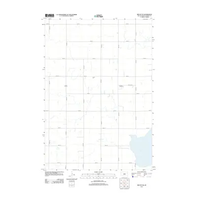
2012 Map of Bryant NE
USGS Topo · Published 2012About this map
Lake Marsh dominates the southeastern portion of this 2012 survey, its expansive waters defining the prairie landscape of eastern South Dakota. The surrounding township is organized by a strict grid of section roads, including 182nd St and 442nd Ave, which facilitate movement through this agricultural heartland. Small pockets of communal history are preserved in the various burial grounds that serve the rural population. Families and genealogists can trace local heritage at the Kellerton Zion Cem, New Hope Lutheran Cem, and the centrally located Pioneer Cem. The presence of these sites, alongside markers like New Hope Rd, reflects the deep-rooted settlement patterns that persist long after the initial frontier period. The map illustrates a landscape of steady production, where the vast majority of land is dedicated to farming, punctuated only by these quiet, protected spaces of local memory.
Find a feature on this map
21 named features on this map. Tap any name to fly to it.
Don’t see what you’re looking for? This feature index may not catch every label — zoom into the map to look around manually.
Map Details
Editions of this 2012 Bryant NE Map
This is the sole edition of this map. No revisions or reprints were ever made.
Other maps of this area

1953 · Watertown
USGS Topo · 1:250,000

1958 · Watertown
USGS Topo · 1:250,000

1969 · Hayti
USGS Topo · 1:24,000

1969 · Lake Norden
USGS Topo · 1:24,000

1969 · Pelican Lake
USGS Topo · 1:24,000

1973 · Bryant NE
USGS Topo · 1:24,000

1973 · Bryant
USGS Topo · 1:24,000
1973 · Gertson Slough
USGS Topo · 1:24,000
1973 · Grover
USGS Topo · 1:24,000

1973 · Vienna East
USGS Topo · 1:24,000
Featured Places
- Opdahl Township, SD
- Oxford Township, SD
- Brantford Township, SD
- Cleveland Township, SD
- Dixon Township, SD