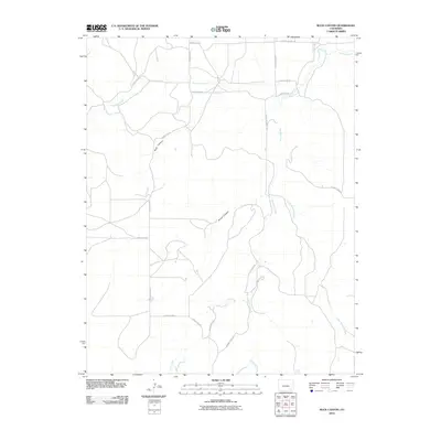
2010 Map of Buck Canyon
USGS Topo · Published 2010About this map
Buck Canyon and Brown Canyon dominate this landscape in southeastern Colorado, where a network of ephemeral watercourses and remote county roads defines the rural geography. The drainage patterns of Two Butte Creek and Mustang Creek intersect a high-plains grid of gravel and dirt routes, including County Rd-70.0 and County Rd-211. The presence of smaller tributaries like Little Mustang Creek and the curiously named O U Creek suggests a territory deeply tied to ranching and livestock movement. This survey captures a moment in the early 21st century when the open range remains largely defined by its natural topography and the sparse infrastructure of the county road system.
Find a feature on this map
20 named features on this map. Tap any name to fly to it.
Don’t see what you’re looking for? This feature index may not catch every label — zoom into the map to look around manually.
Map Details
Editions of this 2010 Buck Canyon Map
This is the sole edition of this map. No revisions or reprints were ever made.
Other maps of this area

1891 · Higbee
USGS Topo · 1:125,000

1892 · Mt Carrizo
USGS Topo · 1:125,000

1893 · Higbee
USGS Topo · 1:125,000

1955 · La Junta
USGS Topo · 1:250,000

1958 · La Junta
USGS Topo · 1:250,000

1968 · La Junta
USGS Topo · 1:250,000
1971 · Walker Canyon
USGS Topo · 1:24,000
1971 · Plug Hat Ranch
USGS Topo · 1:24,000
1972 · Brown Canyon
USGS Topo · 1:24,000

1978 · Utleyville
USGS Topo · 1:24,000