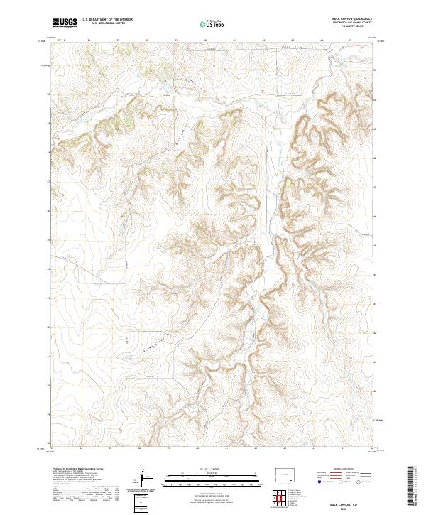
2022 Map of Buck Canyon
USGS Topo · Published 2022About this map
Buck Canyon and Brown Canyon dominate this high plains landscape in Las Animas County, where seasonal watercourses have carved intricate drainage patterns through the terrain. The network of creeks is led by Two Butte Creek in the north and supplemented by Mustang Cr and Little Mustang Cr to the south. This environment is defined by its rural isolation, with a sparse grid of county roads providing the only access to the area's cattle country. These routes, including Co RD 66 and Co RD 211, follow the contours of the land and sections of the Public Land Survey System. The map reveals the relationship between topography and transportation, as most roads avoid the deepest cuts of the canyons, tracing the higher ground between Two Butte Cr and the southern drainages like O U Cr.
Find a feature on this map
26 named features on this map. Tap any name to fly to it.
Don’t see what you’re looking for? This feature index may not catch every label — zoom into the map to look around manually.
Map Details
Editions of this 2022 Buck Canyon Map
This is the sole edition of this map. No revisions or reprints were ever made.
Other maps of this area

1891 · Higbee
USGS Topo · 1:125,000

1892 · Mt Carrizo
USGS Topo · 1:125,000

1893 · Higbee
USGS Topo · 1:125,000

1955 · La Junta
USGS Topo · 1:250,000

1958 · La Junta
USGS Topo · 1:250,000

1968 · La Junta
USGS Topo · 1:250,000
1971 · Walker Canyon
USGS Topo · 1:24,000
1971 · Plug Hat Ranch
USGS Topo · 1:24,000
1972 · Brown Canyon
USGS Topo · 1:24,000

1978 · Utleyville
USGS Topo · 1:24,000