
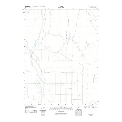
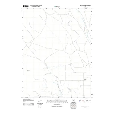
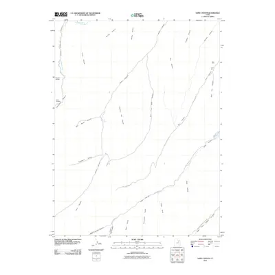
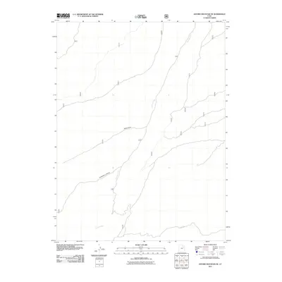
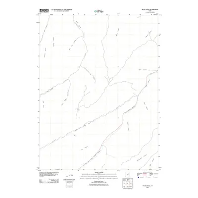
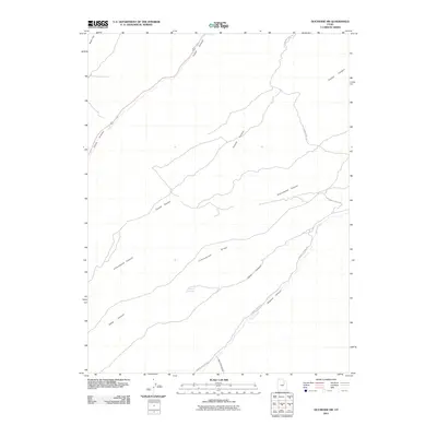
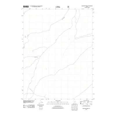
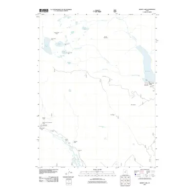
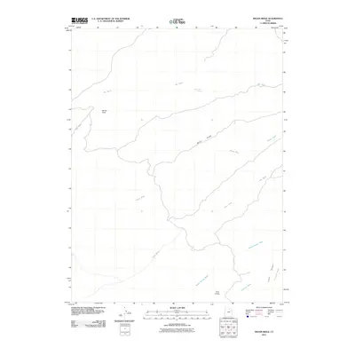
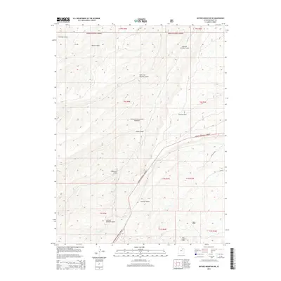
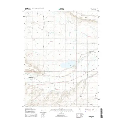
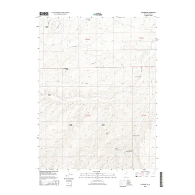
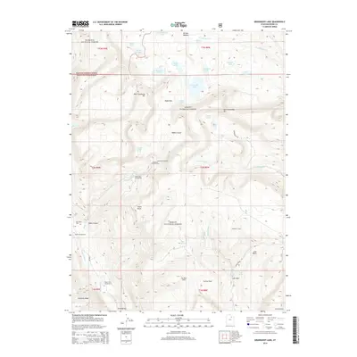
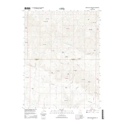
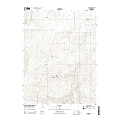
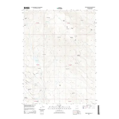
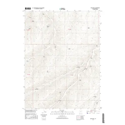
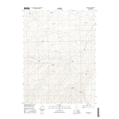
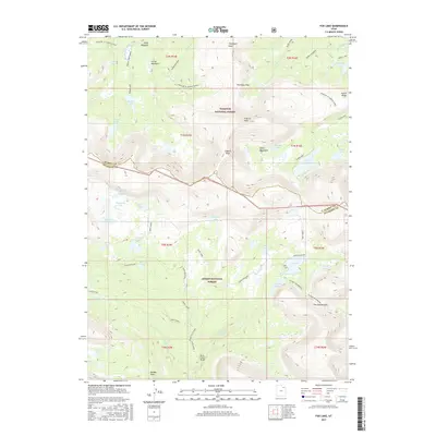
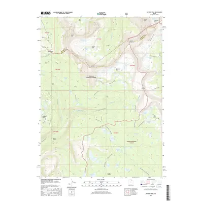
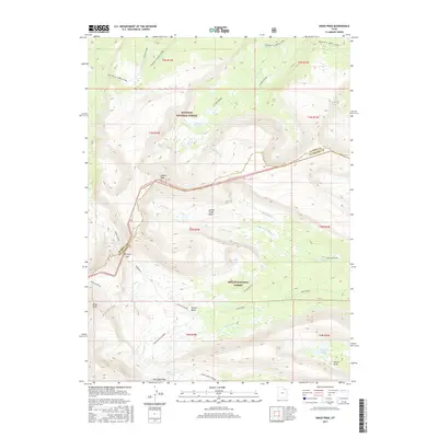
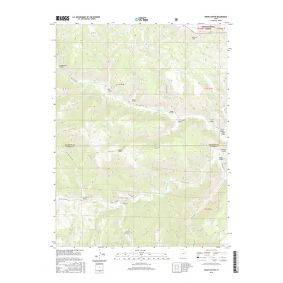
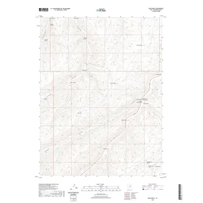
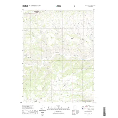
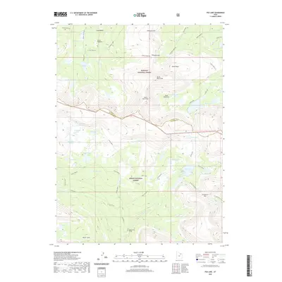
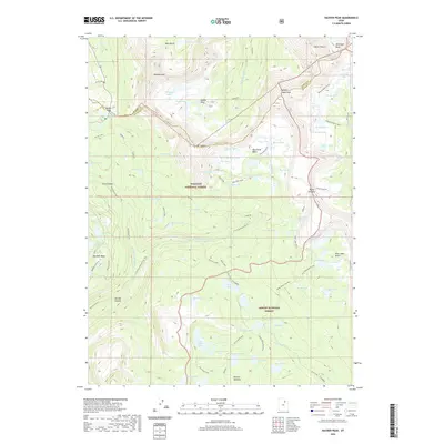
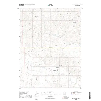
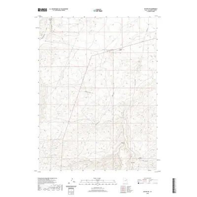
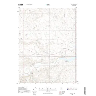
1962 Map of Buck Knoll
USGS Topo · Published 1963About this map
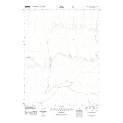
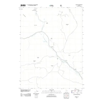
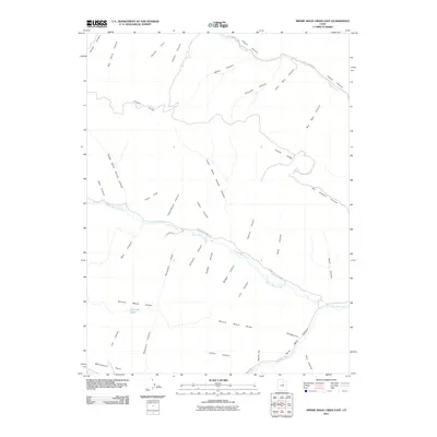
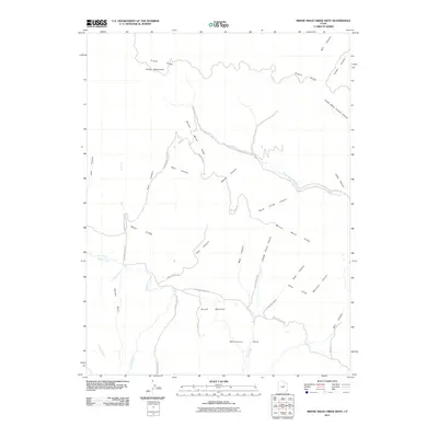
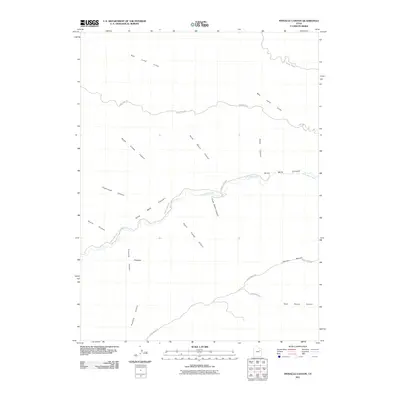
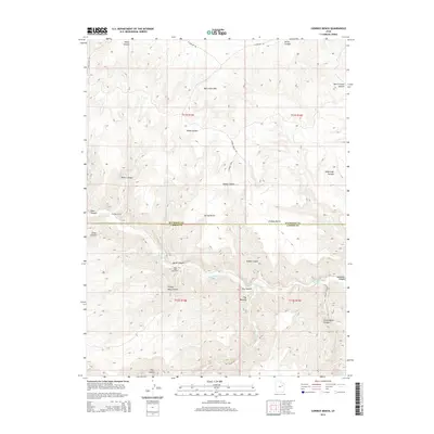
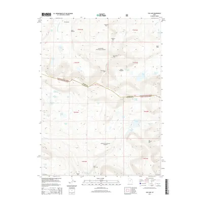
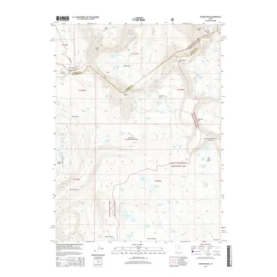
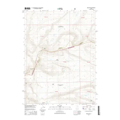
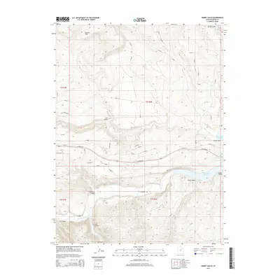
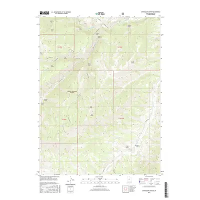
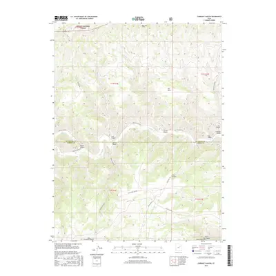
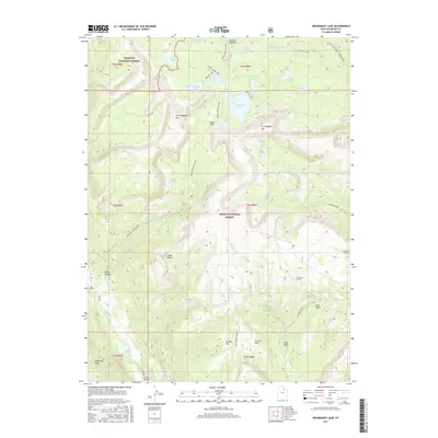
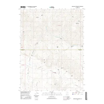
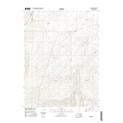
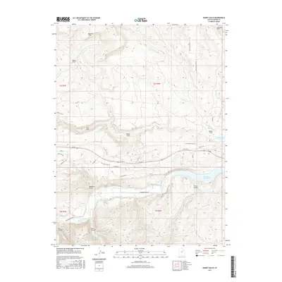
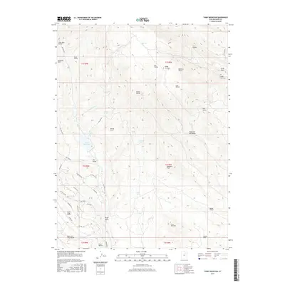
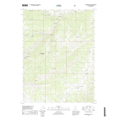
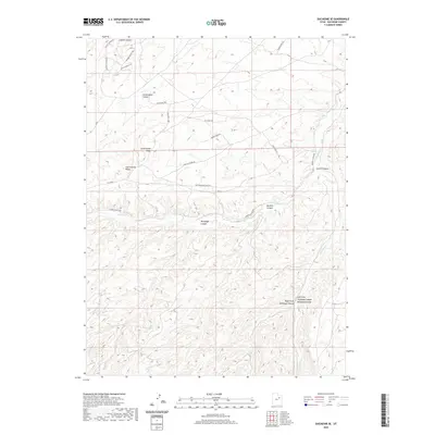
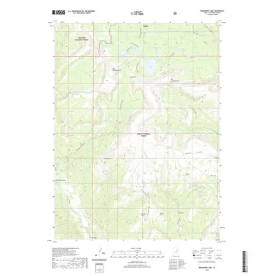
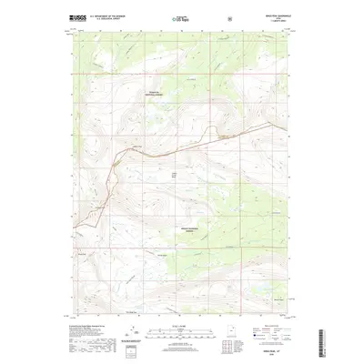
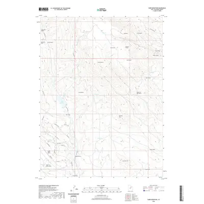
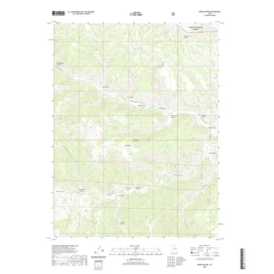
Indian Canyon and its many tributary drainages dominate this mid-century topographic study of Duchesne County. The landscape is defined by a complex network of high-elevation ridges and deep hollows, including Lake Canyon, Matilda Canyon, and Skitzy Canyon. Evidence of mid-century industrial activity is present in the form of the Raven Mine located south of the Right Fork Indian Canyon, along with scattered Oil Wells situated on the higher plateaus near Buck Knoll. The map details a primitive transportation network consisting primarily of an extensive system of Jeep Trails and unnamed roads that navigate the steep terrain between Wolf Den Hollow and Cottonwood Canyon. Water sources are sparse but noted, with Cripple Creek and various Springs providing essential landmarks for the era's surveyors and prospectors.
Find a feature on this map
27 named features on this map. Tap any name to fly to it.
Don’t see what you’re looking for? This feature index may not catch every label — zoom into the map to look around manually.
Map Details
Editions of this 1962 Buck Knoll Map
This is the sole edition of this map. No revisions or reprints were ever made.
Historical Maps of Duchesne County Through Time
343 maps found

1885 Uinta
Duchesne County, UT

1905 Gilbert Peak
Duchesne County, UT

1906 Gilbert Peak
Duchesne County, UT

1962 Avintaquin Canyon
Duchesne County, UT

1962 Blacktail Mtn
Duchesne County, UT
1962 Buck Knoll
Duchesne County, UT

1962 Dry Mountain
Duchesne County, UT

1962 Farm Creek Peak
Duchesne County, UT

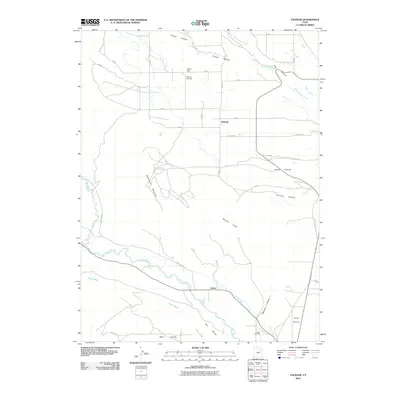
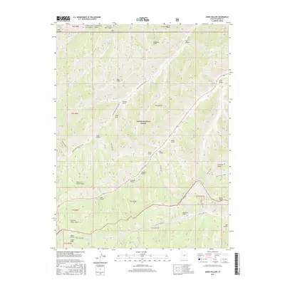
1962 Fruitland
Duchesne County, UT

1962 Hanna
Duchesne County, UT

1962 Rabbit Gulch
Duchesne County, UT

1962 Sams Canyon
Duchesne County, UT

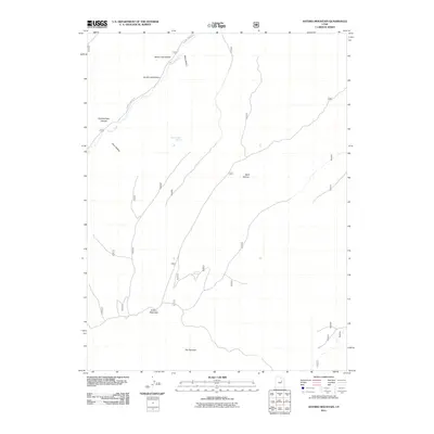
1962 Strawberry Pinnacles
Duchesne County, UT

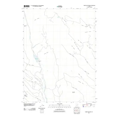
1962 Tabby Mountain
Duchesne County, UT

1964 Bridgeland
Duchesne County, UT

1964 Duchesne NE
Duchesne County, UT

1964 Duchesne SE
Duchesne County, UT

1964 Duchesne SW
Duchesne County, UT

1964 Myton SE
Duchesne County, UT

1964 Myton SW
Duchesne County, UT

1965 Altonah
Duchesne County, UT

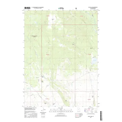
1965 Bollie Lake
Duchesne County, UT

1965 Burnt Mill Spring
Duchesne County, UT

1965 Chepeta Lake
Duchesne County, UT

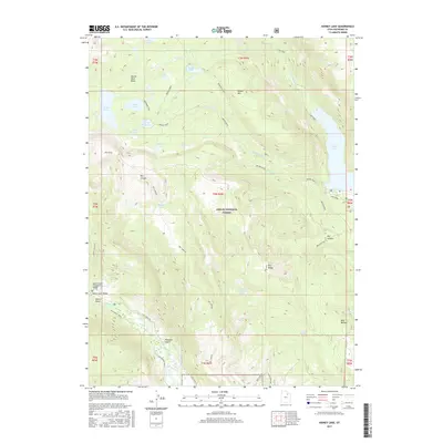
1965 Fox Lake
Duchesne County, UT

1965 Hancock Cove
Duchesne County, UT

1965 Heller Lake
Duchesne County, UT

1965 Kings Peak
Duchesne County, UT

1965 Mountain Home
Duchesne County, UT

1965 Mount Emmons
Duchesne County, UT

1965 Neola NW
Duchesne County, UT

1965 Pole Creek Cave
Duchesne County, UT

1965 Rasmussen Lakes
Duchesne County, UT

1965 Talmage
Duchesne County, UT

1965 Wilkin Ridge
Duchesne County, UT

1967 Explorer Peak
Duchesne County, UT

1967 Garfield Basin
Duchesne County, UT

1967 Kidney Lake
Duchesne County, UT

1967 Lake Fork Mtn
Duchesne County, UT

1967 Oweep Creek
Duchesne County, UT

1967 Tworoose Pass
Duchesne County, UT

1968 Anthro Mtn
Duchesne County, UT

1968 Anthro Mtn NE
Duchesne County, UT

1968 Cowboy Bench
Duchesne County, UT

1968 Currant Canyon
Duchesne County, UT

1968 Gilsonite Draw
Duchesne County, UT

1968 Jones Hollow
Duchesne County, UT

1968 Lance Canyon
Duchesne County, UT

1968 Pinnacle Canyon
Duchesne County, UT

1968 Wood Canyon
Duchesne County, UT

1969 Gray Head Peak
Duchesne County, UT

1969 Minnie Maud Creek East
Duchesne County, UT

1969 Minnie Maud Creek West
Duchesne County, UT

1972 Grandaddy Lake
Duchesne County, UT

1972 Hayden Peak
Duchesne County, UT

1982 Kings Peak
Duchesne County, UT

1996 Anthro Mountain
Duchesne County, UT

1996 Anthro Mountain NE
Duchesne County, UT

1996 Avintaquin Canyon
Duchesne County, UT

1996 Bollie Lake
Duchesne County, UT

1996 Burnt Mill Spring
Duchesne County, UT

1996 Chepeta Lake
Duchesne County, UT

1996 Currant Canyon
Duchesne County, UT

1996 Dark Canyon
Duchesne County, UT

1996 Dry Mountain
Duchesne County, UT

1996 Explorer Peak
Duchesne County, UT

1996 Farm Creek Peak
Duchesne County, UT

1996 Fox Lake
Duchesne County, UT

1996 Garfield Basin
Duchesne County, UT

1996 Gilsonite Draw
Duchesne County, UT

1996 Grandaddy Lake
Duchesne County, UT

1996 Gray Head Peak
Duchesne County, UT

1996 Hanna
Duchesne County, UT

1996 Hayden Peak
Duchesne County, UT

1996 Heller Lake
Duchesne County, UT

1996 Jones Hollow
Duchesne County, UT

1996 Kidney Lake
Duchesne County, UT

1996 Kings Peak
Duchesne County, UT

1996 Lake Fork Mountain
Duchesne County, UT

1996 Lance Canyon
Duchesne County, UT

1996 Mount Emmons
Duchesne County, UT

1996 Rasmussen Lakes
Duchesne County, UT

1996 Wood Canyon
Duchesne County, UT
2010 Altonah
Duchesne County, UT
2010 Blacktail Mountain
Duchesne County, UT
2010 Duchesne SE
Duchesne County, UT
2010 Fruitland
Duchesne County, UT
2010 Mountain Home
Duchesne County, UT
2010 Myton SE
Duchesne County, UT
2010 Myton SW
Duchesne County, UT
2010 Neola NW
Duchesne County, UT
2010 Sams Canyon
Duchesne County, UT

2010 Strawberry Pinnacles
Duchesne County, UT
2010 Tabby Mountain
Duchesne County, UT
2010 Talmage
Duchesne County, UT
2011 Anthro Mountain
Duchesne County, UT
2011 Anthro Mountain NE
Duchesne County, UT
2011 Avintaquin Canyon
Duchesne County, UT
2011 Bollie Lake
Duchesne County, UT
2011 Bridgeland
Duchesne County, UT
2011 Buck Knoll
Duchesne County, UT
2011 Burnt Mill Spring
Duchesne County, UT
2011 Chepeta Lake
Duchesne County, UT
2011 Cowboy Bench
Duchesne County, UT
2011 Currant Canyon
Duchesne County, UT
2011 Dark Canyon
Duchesne County, UT
2011 Dry Mountain
Duchesne County, UT
2011 Duchesne NE
Duchesne County, UT
2011 Duchesne SW
Duchesne County, UT
2011 Explorer Peak
Duchesne County, UT
2011 Farm Creek Peak
Duchesne County, UT

2011 Fox Lake
Duchesne County, UT
2011 Garfield Basin
Duchesne County, UT
2011 Gilsonite Draw
Duchesne County, UT
2011 Grandaddy Lake
Duchesne County, UT
2011 Gray Head Peak
Duchesne County, UT
2011 Hancock Cove
Duchesne County, UT
2011 Hanna
Duchesne County, UT
2011 Hayden Peak
Duchesne County, UT
2011 Heller Lake
Duchesne County, UT
2011 Jones Hollow
Duchesne County, UT
2011 Kidney Lake
Duchesne County, UT
2011 Kings Peak
Duchesne County, UT
2011 Lake Fork Mountain
Duchesne County, UT
2011 Lance Canyon
Duchesne County, UT
2011 Minnie Maud Creek East
Duchesne County, UT
2011 Minnie Maud Creek West
Duchesne County, UT
2011 Mount Emmons
Duchesne County, UT
2011 Oweep Creek
Duchesne County, UT
2011 Pinnacle Canyon
Duchesne County, UT
2011 Rabbit Gulch
Duchesne County, UT
2011 Rasmussen Lakes
Duchesne County, UT
2011 Tworoose Pass
Duchesne County, UT
2011 Wilkin Ridge
Duchesne County, UT
2011 Wood Canyon
Duchesne County, UT
2014 Altonah
Duchesne County, UT
2014 Anthro Mountain
Duchesne County, UT
2014 Anthro Mountain NE
Duchesne County, UT
2014 Avintaquin Canyon
Duchesne County, UT
2014 Blacktail Mountain
Duchesne County, UT
2014 Bollie Lake
Duchesne County, UT
2014 Bridgeland
Duchesne County, UT
2014 Buck Knoll
Duchesne County, UT
2014 Burnt Mill Spring
Duchesne County, UT
2014 Chepeta Lake
Duchesne County, UT
2014 Cowboy Bench
Duchesne County, UT

2014 Currant Canyon
Duchesne County, UT
2014 Dark Canyon
Duchesne County, UT
2014 Dry Mountain
Duchesne County, UT
2014 Duchesne NE
Duchesne County, UT
2014 Duchesne SE
Duchesne County, UT
2014 Duchesne SW
Duchesne County, UT
2014 Explorer Peak
Duchesne County, UT
2014 Farm Creek Peak
Duchesne County, UT
2014 Fox Lake
Duchesne County, UT
2014 Fruitland
Duchesne County, UT
2014 Garfield Basin
Duchesne County, UT
2014 Gilsonite Draw
Duchesne County, UT
2014 Grandaddy Lake
Duchesne County, UT
2014 Gray Head Peak
Duchesne County, UT
2014 Hancock Cove
Duchesne County, UT
2014 Hanna
Duchesne County, UT
2014 Hayden Peak
Duchesne County, UT
2014 Heller Lake
Duchesne County, UT
2014 Jones Hollow
Duchesne County, UT
2014 Kidney Lake
Duchesne County, UT
2014 Kings Peak
Duchesne County, UT
2014 Lake Fork Mountain
Duchesne County, UT
2014 Lance Canyon
Duchesne County, UT
2014 Minnie Maud Creek East
Duchesne County, UT
2014 Minnie Maud Creek West
Duchesne County, UT
2014 Mountain Home
Duchesne County, UT
2014 Mount Emmons
Duchesne County, UT
2014 Myton SE
Duchesne County, UT
2014 Myton SW
Duchesne County, UT
2014 Neola NW
Duchesne County, UT
2014 Oweep Creek
Duchesne County, UT
2014 Pinnacle Canyon
Duchesne County, UT
2014 Rabbit Gulch
Duchesne County, UT
2014 Rasmussen Lakes
Duchesne County, UT
2014 Sams Canyon
Duchesne County, UT
2014 Strawberry Pinnacles
Duchesne County, UT
2014 Tabby Mountain
Duchesne County, UT
2014 Talmage
Duchesne County, UT
2014 Tworoose Pass
Duchesne County, UT
2014 Wilkin Ridge
Duchesne County, UT
2014 Wood Canyon
Duchesne County, UT
2017 Altonah
Duchesne County, UT
2017 Anthro Mountain
Duchesne County, UT
2017 Anthro Mountain NE
Duchesne County, UT
2017 Avintaquin Canyon
Duchesne County, UT
2017 Blacktail Mountain
Duchesne County, UT
2017 Bollie Lake
Duchesne County, UT
2017 Bridgeland
Duchesne County, UT
2017 Buck Knoll
Duchesne County, UT
2017 Burnt Mill Spring
Duchesne County, UT
2017 Chepeta Lake
Duchesne County, UT
2017 Cowboy Bench
Duchesne County, UT
2017 Currant Canyon
Duchesne County, UT
2017 Dark Canyon
Duchesne County, UT
2017 Dry Mountain
Duchesne County, UT
2017 Duchesne NE
Duchesne County, UT
2017 Duchesne SE
Duchesne County, UT
2017 Duchesne SW
Duchesne County, UT
2017 Explorer Peak
Duchesne County, UT
2017 Farm Creek Peak
Duchesne County, UT
2017 Fox Lake
Duchesne County, UT
2017 Fruitland
Duchesne County, UT
2017 Garfield Basin
Duchesne County, UT
2017 Gilsonite Draw
Duchesne County, UT
2017 Grandaddy Lake
Duchesne County, UT
2017 Gray Head Peak
Duchesne County, UT
2017 Hancock Cove
Duchesne County, UT
2017 Hanna
Duchesne County, UT
2017 Hayden Peak
Duchesne County, UT
2017 Heller Lake
Duchesne County, UT
2017 Jones Hollow
Duchesne County, UT
2017 Kidney Lake
Duchesne County, UT
2017 Kings Peak
Duchesne County, UT
2017 Lake Fork Mountain
Duchesne County, UT
2017 Lance Canyon
Duchesne County, UT
2017 Minnie Maud Creek East
Duchesne County, UT
2017 Minnie Maud Creek West
Duchesne County, UT
2017 Mountain Home
Duchesne County, UT
2017 Mount Emmons
Duchesne County, UT
2017 Myton SE
Duchesne County, UT
2017 Myton SW
Duchesne County, UT
2017 Neola NW
Duchesne County, UT
2017 Oweep Creek
Duchesne County, UT
2017 Pinnacle Canyon
Duchesne County, UT
2017 Rabbit Gulch
Duchesne County, UT
2017 Rasmussen Lakes
Duchesne County, UT
2017 Sams Canyon
Duchesne County, UT
2017 Strawberry Pinnacles
Duchesne County, UT
2017 Tabby Mountain
Duchesne County, UT
2017 Talmage
Duchesne County, UT
2017 Tworoose Pass
Duchesne County, UT
2017 Wilkin Ridge
Duchesne County, UT
2017 Wood Canyon
Duchesne County, UT
2020 Altonah
Duchesne County, UT
2020 Anthro Mountain
Duchesne County, UT
2020 Anthro Mountain NE
Duchesne County, UT
2020 Avintaquin Canyon
Duchesne County, UT
2020 Blacktail Mountain
Duchesne County, UT
2020 Bollie Lake
Duchesne County, UT
2020 Bridgeland
Duchesne County, UT
2020 Buck Knoll
Duchesne County, UT
2020 Burnt Mill Spring
Duchesne County, UT
2020 Chepeta Lake
Duchesne County, UT
2020 Cowboy Bench
Duchesne County, UT
2020 Currant Canyon
Duchesne County, UT
2020 Dark Canyon
Duchesne County, UT
2020 Dry Mountain
Duchesne County, UT
2020 Duchesne NE
Duchesne County, UT
2020 Duchesne SE
Duchesne County, UT
2020 Duchesne SW
Duchesne County, UT
2020 Explorer Peak
Duchesne County, UT
2020 Farm Creek Peak
Duchesne County, UT
2020 Fox Lake
Duchesne County, UT
2020 Fruitland
Duchesne County, UT
2020 Garfield Basin
Duchesne County, UT
2020 Gilsonite Draw
Duchesne County, UT
2020 Grandaddy Lake
Duchesne County, UT
2020 Gray Head Peak
Duchesne County, UT
2020 Hancock Cove
Duchesne County, UT
2020 Hanna
Duchesne County, UT
2020 Hayden Peak
Duchesne County, UT
2020 Heller Lake
Duchesne County, UT
2020 Jones Hollow
Duchesne County, UT
2020 Kidney Lake
Duchesne County, UT
2020 Kings Peak
Duchesne County, UT
2020 Lake Fork Mountain
Duchesne County, UT
2020 Lance Canyon
Duchesne County, UT
2020 Minnie Maud Creek East
Duchesne County, UT
2020 Minnie Maud Creek West
Duchesne County, UT
2020 Mountain Home
Duchesne County, UT
2020 Mount Emmons
Duchesne County, UT
2020 Myton SE
Duchesne County, UT
2020 Myton SW
Duchesne County, UT
2020 Neola NW
Duchesne County, UT
2020 Oweep Creek
Duchesne County, UT
2020 Pinnacle Canyon
Duchesne County, UT
2020 Rabbit Gulch
Duchesne County, UT
2020 Rasmussen Lakes
Duchesne County, UT
2020 Sams Canyon
Duchesne County, UT
2020 Strawberry Pinnacles
Duchesne County, UT
2020 Tabby Mountain
Duchesne County, UT
2020 Talmage
Duchesne County, UT
2020 Tworoose Pass
Duchesne County, UT
2020 Wilkin Ridge
Duchesne County, UT
2020 Wood Canyon
Duchesne County, UT

2023 Altonah
Duchesne County, UT

2023 Anthro Mountain
Duchesne County, UT

2023 Anthro Mountain NE
Duchesne County, UT

2023 Avintaquin Canyon
Duchesne County, UT

2023 Blacktail Mountain
Duchesne County, UT

2023 Bollie Lake
Duchesne County, UT

2023 Bridgeland
Duchesne County, UT

2023 Buck Knoll
Duchesne County, UT

2023 Burnt Mill Spring
Duchesne County, UT

2023 Chepeta Lake
Duchesne County, UT

2023 Cowboy Bench
Duchesne County, UT

2023 Currant Canyon
Duchesne County, UT

2023 Dark Canyon
Duchesne County, UT

2023 Dry Mountain
Duchesne County, UT

2023 Duchesne NE
Duchesne County, UT

2023 Duchesne SE
Duchesne County, UT

2023 Duchesne SW
Duchesne County, UT

2023 Explorer Peak
Duchesne County, UT

2023 Farm Creek Peak
Duchesne County, UT

2023 Fox Lake
Duchesne County, UT

2023 Fruitland
Duchesne County, UT

2023 Garfield Basin
Duchesne County, UT

2023 Gilsonite Draw
Duchesne County, UT

2023 Grandaddy Lake
Duchesne County, UT

2023 Gray Head Peak
Duchesne County, UT

2023 Hancock Cove
Duchesne County, UT

2023 Hanna
Duchesne County, UT

2023 Hayden Peak
Duchesne County, UT

2023 Heller Lake
Duchesne County, UT

2023 Jones Hollow
Duchesne County, UT

2023 Kidney Lake
Duchesne County, UT

2023 Kings Peak
Duchesne County, UT

2023 Lake Fork Mountain
Duchesne County, UT

2023 Lance Canyon
Duchesne County, UT

2023 Minnie Maud Creek East
Duchesne County, UT

2023 Minnie Maud Creek West
Duchesne County, UT

2023 Mountain Home
Duchesne County, UT

2023 Mount Emmons
Duchesne County, UT

2023 Myton SE
Duchesne County, UT

2023 Myton SW
Duchesne County, UT

2023 Neola NW
Duchesne County, UT

2023 Oweep Creek
Duchesne County, UT

2023 Pinnacle Canyon
Duchesne County, UT

2023 Rabbit Gulch
Duchesne County, UT

2023 Rasmussen Lakes
Duchesne County, UT

2023 Sams Canyon
Duchesne County, UT

2023 Strawberry Pinnacles
Duchesne County, UT

2023 Tabby Mountain
Duchesne County, UT

2023 Talmage
Duchesne County, UT

2023 Tworoose Pass
Duchesne County, UT

2023 Wilkin Ridge
Duchesne County, UT

2023 Wood Canyon
Duchesne County, UT