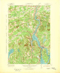
1942 Map of Bucksport
USGS Topo · Published 1942About this map
The Penobscot River serves as the central artery for this 1942 coastal survey, defining the industrial and social boundaries between Waldo, Penobscot, and Hancock counties. Near the narrows of the river stands the formidable Fort Knox, positioned across from the village of Bucksport. This era shows a landscape where maritime transport and rail infrastructure intersect, with the Bangor and Aroostook RR tracing the eastern bank through Orrington and South Orrington. The river's edge is dotted with coves and points like Collins Cove and Oak Pt, while the interior terrain is marked by granite peaks such as Mt Waldo and Heagan Mt.
Find a feature on this map
84 named features on this map. Tap any name to fly to it.
Don’t see what you’re looking for? This feature index may not catch every label — zoom into the map to look around manually.
Map Details
Editions of this 1942 Bucksport Map
This is the sole edition of this map. No revisions or reprints were ever made.
Other maps of this area

1900 · Orland
USGS Topo · 1:62,500

1900 · Bucksport
USGS Topo · 1:62,500

1902 · Orono
USGS Topo · 1:62,500

1902 · Bucksport
USGS Topo · 1:62,500

1902 · Bangor
USGS Topo · 1:62,500

1902 · Castine
USGS Topo · 1:62,500

1904 · Castine
USGS Topo · 1:62,500
1904 · Bluehill
USGS Topo · 1:62,500

1905 · Penobscot Bay
USGS Topo · 1:125,000
1915 · Belfast
USGS Topo · 1:62,500