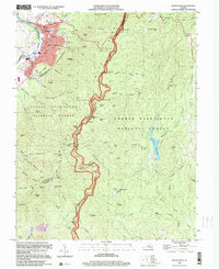
1999 Map of Buena Vista
USGS Topo · Published 2000About this map
The industrial and academic hub of Buena Vista anchors this landscape where the Maury River meets the steep ascent of the Blue Ridge. At the turn of the millennium, the city layout reveals a transition from the riverfront Sewage Disposal and athletic facilities to the historic campus of Southern Seminary Jr College and McCluer High Sch. To the east, the map documents the high-altitude transit corridor of the Blue Ridge Parkway, which winds along the crest through the George Washington National Forest. This ridge serves as a major recreational artery, dotted with scenic viewpoints like the House Mountains Overlook and the Rice Mtn Overlook. Further into the forest, the Appalachian Trail follows the remote terrain past the Brown Mtn Creek Shelter, while the Lynchburg Reservoir sits tucked within the eastern valleys, providing a critical water source for the region.
Find a feature on this map
102 named features on this map. Tap any name to fly to it.
Don’t see what you’re looking for? This feature index may not catch every label — zoom into the map to look around manually.
Map Details
Editions of this 1999 Buena Vista Map
This is the sole edition of this map. No revisions or reprints were ever made.
Other maps of this area

1894 · Lexington
USGS Topo · 1:125,000

1932 · Lexington
USGS Topo · 1:48,000

1935 · Buena Vista
USGS Topo · 1:48,000

1935 · Amherst
USGS Topo · 1:48,000

1936 · Vesuvius
USGS Topo · 1:48,000

1937 · Lexington
USGS Topo · 1:62,500

1939 · Amherst
USGS Topo · 1:62,500

1939 · Buena Vista
USGS Topo · 1:62,500

1940 · Buena Vista
USGS Topo · 1:62,500

1941 · Vesuvius
USGS Topo · 1:62,500