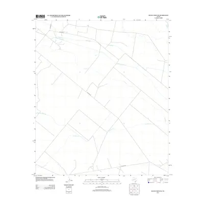
2012 Map of Buena Vista NE
USGS Topo · Published 2012About this map
The Highline Canal and multiple branches of the Imperial Canal system dictate the layout of this West Texas landscape, illustrating the critical role of water management in Pecos County. In this arid region, the straight-line geometry of irrigation infrastructure like Imperial Canal Number Five and Imperial Canal Number Three contrasts sharply with the wandering, intermittent paths of Comanche Cr and Leon Cr. The presence of these canals alongside early transportation routes such as Old Crane Rd and Old Girvin Rd reflects the era's reliance on both water and road networks to support local ranching and agricultural operations. Major corridors like Ranch Road 11 and Woodward Rd provide the primary modern access across this sparsely settled terrain, connecting the watershed features to the broader regional economy.
Find a feature on this map
9 named features on this map. Tap any name to fly to it.
Don’t see what you’re looking for? This feature index may not catch every label — zoom into the map to look around manually.
Map Details
Editions of this 2012 Buena Vista NE Map
This is the sole edition of this map. No revisions or reprints were ever made.
Other maps of this area

1928 · Crane
USGS Topo · 1:125,000

1954 · Pecos
USGS Topo · 1:250,000

1957 · Pecos
USGS Topo · 1:250,000
1972 · Buena Vista NE
USGS Topo · 1:24,000
1972 · Buena Vista SW
USGS Topo · 1:24,000
1972 · Girvin
USGS Topo · 1:24,000
1972 · Owego
USGS Topo · 1:24,000
1972 · Buena Vista
USGS Topo · 1:24,000
1972 · Girvin NW
USGS Topo · 1:24,000

1974 · Crane SW
USGS Topo · 1:24,000