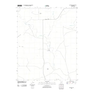
2010 Map of Bueyeros
USGS Topo · Published 2010About this map
Bueyeros and its surrounding ranching landscape in Harding County are defined by the winding course of Ute Creek. This 2010 map records a unique pattern of named settlements and land tracts, including Miera and Schwartz, which reflect the specific lineage of local land use. Distinctive labels such as Danube Number One Beller and Colo Mex Number Two FC Debaca suggest a complex history of property divisions or agricultural projects within the canyon-and-mesa terrain. The geography transitions from the elevated Mesa Quitaras down into the drainage basins of Salado Creek and Bueyeros Creek, while the Bueyeros Post Office remains a central landmark for this rural community. The road network, including County Road L, connects these disparate settlements across the high plains environment.
Find a feature on this map
19 named features on this map. Tap any name to fly to it.
Don’t see what you’re looking for? This feature index may not catch every label — zoom into the map to look around manually.
Map Details
Editions of this 2010 Bueyeros Map
This is the sole edition of this map. No revisions or reprints were ever made.
Other maps of this area

1954 · Tucumcari
USGS Topo · 1:250,000

1954 · Dalhart
USGS Topo · 1:250,000

1958 · Tucumcari
USGS Topo · 1:250,000

1958 · Dalhart
USGS Topo · 1:250,000

1962 · Dalhart
USGS Topo · 1:250,000

1973 · Bueyeros NE
USGS Topo · 1:24,000

1973 · Circle Bar Ranch
USGS Topo · 1:24,000
1973 · Indian Bathtub
USGS Topo · 1:24,000

1973 · Yates SE
USGS Topo · 1:24,000
1973 · Minnie Butte
USGS Topo · 1:24,000