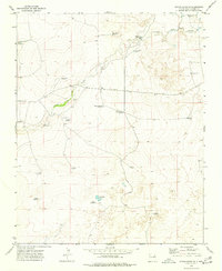
1973 Map of Indian Bathtub
USGS Topo · Published 1977About this map
Cejita Cem and the distinctive Indian Bathtub water feature anchor this 1970s topographic study of Harding County. The landscape is defined by the ephemeral Arroyo de la Cejita and a series of water management points essential for high-plains ranching. Family-named landmarks such as Lopez Well No 1 and Harris Windmills illustrate the importance of water rights and private landholding in this arid region. The presence of both the West Graveyard Windmill and East Graveyard Windmill near the central drainage suggest a localized concentration of activity around the Cejita terrain. Other remote features like the Salt Lakes and Salada Windmill further emphasize the alkali and saline characteristics of the local hydrology during this period.
Find a feature on this map
23 named features on this map. Tap any name to fly to it.
Don’t see what you’re looking for? This feature index may not catch every label — zoom into the map to look around manually.
Map Details
Editions of this 1973 Indian Bathtub Map
This is the sole edition of this map. No revisions or reprints were ever made.
Other maps of this area

1954 · Tucumcari
USGS Topo · 1:250,000

1958 · Tucumcari
USGS Topo · 1:250,000

1966 · Rosebud
USGS Topo · 1:24,000

1966 · Cottonwood Springs
USGS Topo · 1:24,000

1966 · Mc Cloy Ranch
USGS Topo · 1:24,000

1969 · Gallegos NE
USGS Topo · 1:24,000

1969 · Buffalo Springs
USGS Topo · 1:24,000

1973 · Bueyeros NE
USGS Topo · 1:24,000

1973 · Circle Bar Ranch
USGS Topo · 1:24,000
1973 · Bueyeros
USGS Topo · 1:24,000