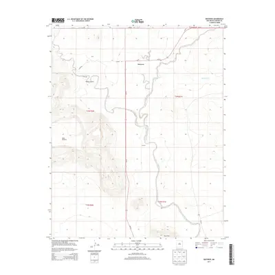
2013 Map of Bueyeros
USGS Topo · Published 2013About this map
Bueyeros serves as the focal point of this high plains landscape in Harding County, where the village and its Po sit at the intersection of NM-102 and Campbell Rd. The topography is defined by the dramatic escarpment of Mesa Quitaras to the west and the winding drainage of Del Muerto Cr to the east. Small settlements and named locales like Miera, Schwartz, and Libby are scattered across the terrain, connected by a network of ranch roads including Gallagher Rd and Nestor Rd. This 2013 survey illustrates the enduring rural character of northeastern New Mexico, where land use is dictated by the rugged breaks of Asperos Canyon and the elevated reach of the Black Hills. The map provides clear evidence of long-standing family and ranching footprints through specific labels such as Stinbaugh and Gap Rd.
Find a feature on this map
22 named features on this map. Tap any name to fly to it.
Don’t see what you’re looking for? This feature index may not catch every label — zoom into the map to look around manually.
Map Details
Editions of this 2013 Bueyeros Map
This is the sole edition of this map. No revisions or reprints were ever made.
Other maps of this area

1954 · Tucumcari
USGS Topo · 1:250,000

1954 · Dalhart
USGS Topo · 1:250,000

1958 · Tucumcari
USGS Topo · 1:250,000

1958 · Dalhart
USGS Topo · 1:250,000

1962 · Dalhart
USGS Topo · 1:250,000

1973 · Bueyeros NE
USGS Topo · 1:24,000

1973 · Circle Bar Ranch
USGS Topo · 1:24,000
1973 · Indian Bathtub
USGS Topo · 1:24,000

1973 · Yates SE
USGS Topo · 1:24,000
1973 · Minnie Butte
USGS Topo · 1:24,000