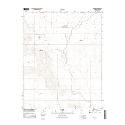
2017 Map of Bueyeros
USGS Topo · Published 2017About this map
Bueyeros stands as a focal point in this high plains landscape of northeastern New Mexico, where the terrain transitions into complex drainage systems and prominent landforms. The settlement is positioned along Gap Rd, near the head of a winding waterway that feeds into the broader basin. To the west, the massive uplift of Mesa Quitaras dominates the horizon, while the deeply incised Asperos Canyon and the southern Black Hills demonstrate the erosional forces typical of this arid region. The drainage of Del Muerto Cr cuts through the eastern portion of the survey, highlighting the sparse but vital water networks that once dictated ranching and settlement patterns. A grid of local routes like Gallagher Rd and Campbell Rd provides the primary infrastructure connecting these remote homesteads and grazing lands.
Find a feature on this map
16 named features on this map. Tap any name to fly to it.
Don’t see what you’re looking for? This feature index may not catch every label — zoom into the map to look around manually.
Map Details
Editions of this 2017 Bueyeros Map
This is the sole edition of this map. No revisions or reprints were ever made.
Other maps of this area

1954 · Tucumcari
USGS Topo · 1:250,000

1954 · Dalhart
USGS Topo · 1:250,000

1958 · Tucumcari
USGS Topo · 1:250,000

1958 · Dalhart
USGS Topo · 1:250,000

1962 · Dalhart
USGS Topo · 1:250,000

1973 · Bueyeros NE
USGS Topo · 1:24,000

1973 · Circle Bar Ranch
USGS Topo · 1:24,000
1973 · Indian Bathtub
USGS Topo · 1:24,000

1973 · Yates SE
USGS Topo · 1:24,000
1973 · Minnie Butte
USGS Topo · 1:24,000