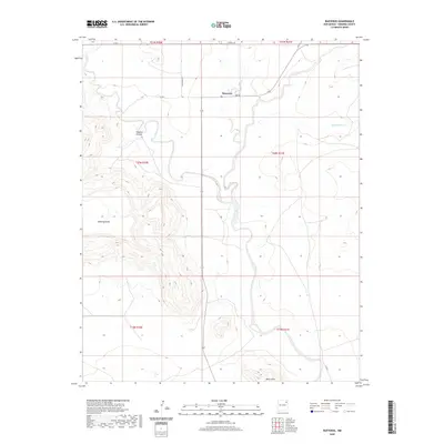
2020 Map of Bueyeros
USGS Topo · Published 2020About this map
Bueyeros sits as the central point of reference in this High Plains landscape, situated where the high tablelands of Mesa Quitaras meet the drainage networks of the Canadian River watershed. This northeastern New Mexico territory is defined by its dramatic relief, where the flat upland surfaces are abruptly interrupted by the deep incisions of Asperos Canyon and the winding course of Del Muerto Cr. The settlement pattern reflects the traditional ranching economy of Harding County, with a sparse network of roads like Gap Rd and Gallagher Rd connecting isolated homesteads across the townships. To the south, the Black Hills rise above the surrounding terrain, marking a distinct geological transition in a region characterized by its expansive mesas and deep canyon draws.
Find a feature on this map
16 named features on this map. Tap any name to fly to it.
Don’t see what you’re looking for? This feature index may not catch every label — zoom into the map to look around manually.
Map Details
Editions of this 2020 Bueyeros Map
This is the sole edition of this map. No revisions or reprints were ever made.
Other maps of this area

1954 · Tucumcari
USGS Topo · 1:250,000

1954 · Dalhart
USGS Topo · 1:250,000

1958 · Tucumcari
USGS Topo · 1:250,000

1958 · Dalhart
USGS Topo · 1:250,000

1962 · Dalhart
USGS Topo · 1:250,000

1973 · Bueyeros NE
USGS Topo · 1:24,000

1973 · Circle Bar Ranch
USGS Topo · 1:24,000
1973 · Indian Bathtub
USGS Topo · 1:24,000

1973 · Yates SE
USGS Topo · 1:24,000
1973 · Minnie Butte
USGS Topo · 1:24,000