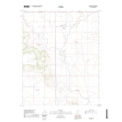
2023 Map of Bueyeros
USGS Topo · Published 2023About this map
Bueyeros serves as the central point of this northeastern New Mexico ranching landscape, situated at the intersection of Gap Rd and Gallagher Rd. The community’s spiritual and historical focus is the Sacred Heart Catholic Church Cem, a landmark for local genealogists and historians. The terrain transitions from the high, flat-topped Mesa Quitaras in the west to the drainage of Del Muerto Creek in the east. To the south, the Black Hills rise near the southern range line, while Asperos Canyon cuts through the mesa edges. This map provides a detailed view of the modern rural infrastructure, showing the sparse network of county roads like Campbell Rd that connect the isolated homesteads and grazing lands typical of Harding County.
Find a feature on this map
18 named features on this map. Tap any name to fly to it.
Don’t see what you’re looking for? This feature index may not catch every label — zoom into the map to look around manually.
Map Details
Editions of this 2023 Bueyeros Map
This is the sole edition of this map. No revisions or reprints were ever made.
Other maps of this area

1954 · Tucumcari
USGS Topo · 1:250,000

1954 · Dalhart
USGS Topo · 1:250,000

1958 · Tucumcari
USGS Topo · 1:250,000

1958 · Dalhart
USGS Topo · 1:250,000

1962 · Dalhart
USGS Topo · 1:250,000

1973 · Bueyeros NE
USGS Topo · 1:24,000

1973 · Circle Bar Ranch
USGS Topo · 1:24,000
1973 · Indian Bathtub
USGS Topo · 1:24,000

1973 · Yates SE
USGS Topo · 1:24,000
1973 · Minnie Butte
USGS Topo · 1:24,000