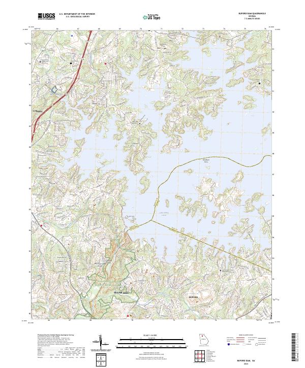
2024 Map of Buford Dam
USGS Topo · Published 2024About this map
Lake Sidney Lanier dominates this modern study of the Georgia Piedmont, where the reservoir's complex fingers reach into Forsyth, Hall, and Gwinnett Counties. The landscape is defined by the massive infrastructure of Buford Dam Rd and the Chattahoochee River National Recreation Area, protecting the river corridor below the dam near Bowmans Island. This area serves as a critical boundary zone where the suburban growth of Cumming, Sugar Hill, and Buford meets the water-based geography of the reservoir.
Find a feature on this map
65 named features on this map. Tap any name to fly to it.
Don’t see what you’re looking for? This feature index may not catch every label — zoom into the map to look around manually.
Map Details
Editions of this 2024 Buford Dam Map
This is the sole edition of this map. No revisions or reprints were ever made.
Other maps of this area

1890 · Suwanee
USGS Topo · 1:125,000

1891 · Gainesville
USGS Topo · 1:125,000

1894 · Suwanee
USGS Topo · 1:125,000

1954 · Greenville
USGS Topo · 1:250,000

1955 · Rome
USGS Topo · 1:250,000

1956 · Duluth
USGS Topo · 1:24,000

1958 · Greenville
USGS Topo · 1:250,000

1958 · Rome
USGS Topo · 1:250,000

1961 · Rome
USGS Topo · 1:250,000

1963 · Rome
USGS Topo · 1:250,000