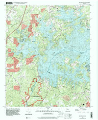
1993 Map of Buford Dam
USGS Topo · Published 2000About this map
Buford Dam anchors the landscape of this Georgia quadrangle, holding the waters of Lake Sidney Lanier at a normal pool elevation of 1070 feet. The extensive shoreline created by the reservoir has transformed the local geography, giving rise to numerous recreation areas such as Charleston Campground, Bald Ridge Marina, and Sawnee Campground. Despite the rising waters, older patterns of life remain visible through upland landmarks like Chattahoochee Sch and a network of country churches including Ebenezer Ch, Piedmont Ch, and Corinth Ch. To the south, the river resumes its natural course below the dam, winding past Bowmans Island and through the Chattahoochee River National Recreation Area. This map documents a transitional period where suburban growth and modern recreational infrastructure began to overlay the traditional rural communities and family cemeteries of Forsyth, Gwinnett, and Hall counties.
Find a feature on this map
66 named features on this map. Tap any name to fly to it.
Don’t see what you’re looking for? This feature index may not catch every label — zoom into the map to look around manually.
Map Details
Editions of this 1993 Buford Dam Map
This is the sole edition of this map. No revisions or reprints were ever made.
Other maps of this area

1890 · Suwanee
USGS Topo · 1:125,000

1891 · Gainesville
USGS Topo · 1:125,000

1894 · Suwanee
USGS Topo · 1:125,000

1954 · Greenville
USGS Topo · 1:250,000

1955 · Rome
USGS Topo · 1:250,000

1956 · Duluth
USGS Topo · 1:24,000

1958 · Greenville
USGS Topo · 1:250,000

1958 · Rome
USGS Topo · 1:250,000

1961 · Rome
USGS Topo · 1:250,000

1963 · Rome
USGS Topo · 1:250,000