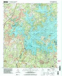
1999 Map of Buford Dam
USGS Topo · Published 2003About this map
Lake Sidney Lanier dominates the landscape where the corners of Forsyth, Hall, and Gwinnett counties meet, shaped by the massive Buford Dam at the southern end of the reservoir. This late-century update reveals a region defined by water-based recreation and utility, with the Chattahoochee River flowing south from the dam through the Chattahoochee River National Recreation Area. Local spiritual life is well-documented through several historic congregations, including Antioch Ch and Ebenezer Ch near the city of Cumming, and Beaver Ruin Ch tucked among the fingers of the lake. The map details a complex shoreline of inlets and islands, such as Bowmans Island and Island Ford, alongside modern infrastructure like the Buford Trout Hatchery and numerous campgrounds that transformed this river valley into a major recreational hub.
Find a feature on this map
60 named features on this map. Tap any name to fly to it.
Don’t see what you’re looking for? This feature index may not catch every label — zoom into the map to look around manually.
Map Details
Editions of this 1999 Buford Dam Map
This is the sole edition of this map. No revisions or reprints were ever made.
Other maps of this area

1890 · Suwanee
USGS Topo · 1:125,000

1891 · Gainesville
USGS Topo · 1:125,000

1894 · Suwanee
USGS Topo · 1:125,000

1954 · Greenville
USGS Topo · 1:250,000

1955 · Rome
USGS Topo · 1:250,000

1956 · Duluth
USGS Topo · 1:24,000

1958 · Greenville
USGS Topo · 1:250,000

1958 · Rome
USGS Topo · 1:250,000

1961 · Rome
USGS Topo · 1:250,000

1963 · Rome
USGS Topo · 1:250,000