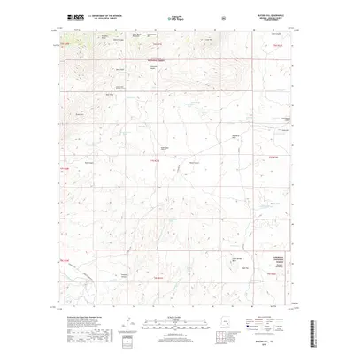
2018 Map of Buford Hill
USGS Topo · Published 2018About this map
Coronado National Forest dominates the high desert landscape of Graham County, where the transition between the Santa Teresa Mountains and the Pinaleno Mountains creates a complex system of drainage and relief. This 2018 survey documents a remote ranching and wilderness area defined by essential water sources, including Devils Hole, Cherry Tree Spring, and Crazy Horse Spring. The presence of numerous stock tanks, such as Goat Water Tank and Register Tank, illustrates the ongoing agricultural utility of the land despite its steep verticality. In the southern portion of the quadrangle, the dramatic drop into Aravaipa Canyon and the winding course of Aravaipa Cr mark a significant geological shift. Transportation in this area remains sparse, centered on the historic route of W Klondyke Rd, which skirts the base of landmarks like Buford Hill and Oak Butte.
Find a feature on this map
57 named features on this map. Tap any name to fly to it.
Don’t see what you’re looking for? This feature index may not catch every label — zoom into the map to look around manually.
Map Details
Editions of this 2018 Buford Hill Map
This is the sole edition of this map. No revisions or reprints were ever made.
Other maps of this area

1938 · Galiuro Mts
USGS Topo · 1:48,000

1938 · Klondyke
USGS Topo · 1:48,000

1940 · Sierra Bonita Ranch
USGS Topo · 1:62,500

1942 · Sierra Bonita Ranch
USGS Topo · 1:62,500

1943 · Galiuro Mts
USGS Topo · 1:62,500

1943 · Klondyke
USGS Topo · 1:62,500

1943 · Sierra Bonita Ranch
USGS Topo · 1:62,500

1944 · Jackson Mtn.
USGS Topo · 1:62,500

1946 · Jackson Mtn.
USGS Topo · 1:62,500

1956 · Tucson
USGS Topo · 1:250,000