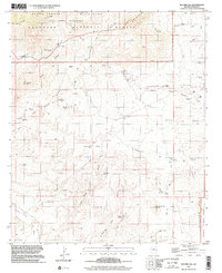
1997 Map of Buford Hill
USGS Topo · Published 2002About this map
The Santa Teresa Wilderness and the Coronado National Forest dominate this landscape in Graham County, where high desert elevations meet complex drainages. Topography compiled in 1971 and updated with late-1990s imagery shows a land defined by water management and rugged relief, ranging from the Santa Teresa Ridge to the Pinaleno Mountains. Remote livestock and wildlife infrastructure is visible through numerous named catchments like Lee Tank, Buford Tank, and Goat Water Tank.
Find a feature on this map
57 named features on this map. Tap any name to fly to it.
Don’t see what you’re looking for? This feature index may not catch every label — zoom into the map to look around manually.
Map Details
Editions of this 1997 Buford Hill Map
This is the sole edition of this map. No revisions or reprints were ever made.
Other maps of this area

1938 · Galiuro Mts
USGS Topo · 1:48,000

1938 · Klondyke
USGS Topo · 1:48,000

1940 · Sierra Bonita Ranch
USGS Topo · 1:62,500

1942 · Sierra Bonita Ranch
USGS Topo · 1:62,500

1943 · Galiuro Mts
USGS Topo · 1:62,500

1943 · Klondyke
USGS Topo · 1:62,500

1943 · Sierra Bonita Ranch
USGS Topo · 1:62,500

1944 · Jackson Mtn.
USGS Topo · 1:62,500

1946 · Jackson Mtn.
USGS Topo · 1:62,500

1956 · Tucson
USGS Topo · 1:250,000