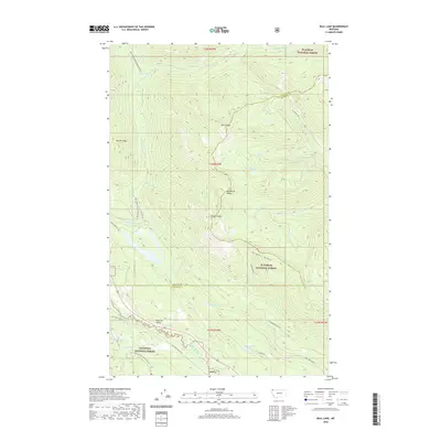
2020 Map of Bull Lake
USGS Topo · Published 2020About this map
The Stillwater River winds through the heart of the Whitefish Range on this modern survey of northwest Montana. This high-country landscape is defined by its prominent summits, including Herrig Mtn and Stryker Peak, which separate the various drainage basins of Fitzsimmons Cr and Hellroaring Cr. The area is shared by the Flathead National Forest and Kootenai National Forest, with the county line between Lincoln and Flathead dividing the map. Evidence of early transit across these mountains remains visible through the Old Fort Steele Trl and the Point of Rocks landmark. Numerous high-elevation water bodies like Spring Lakes, Sunday Lakes, and Woods Lake dot the terrain, while established access routes like Bull Lake Rd and Fitzsimmons Creek Rd provide the primary entries into this mountainous forest land.
Find a feature on this map
30 named features on this map. Tap any name to fly to it.
Don’t see what you’re looking for? This feature index may not catch every label — zoom into the map to look around manually.
Map Details
Editions of this 2020 Bull Lake Map
This is the sole edition of this map. No revisions or reprints were ever made.
Other maps of this area

1913 · Stryker
USGS Topo · 1:125,000

1916 · Stryker
USGS Topo · 1:125,000

1957 · Kalispell
USGS Topo · 1:250,000

1960 · Kalispell
USGS Topo · 1:250,000

1961 · Kalispell
USGS Topo · 1:250,000

1963 · Mount Marston
USGS Topo · 1:24,000

1963 · Stryker
USGS Topo · 1:24,000

1963 · Sunday Mountain
USGS Topo · 1:24,000
1966 · Radnor
USGS Topo · 1:24,000

1966 · Red Meadow Lake
USGS Topo · 1:24,000